
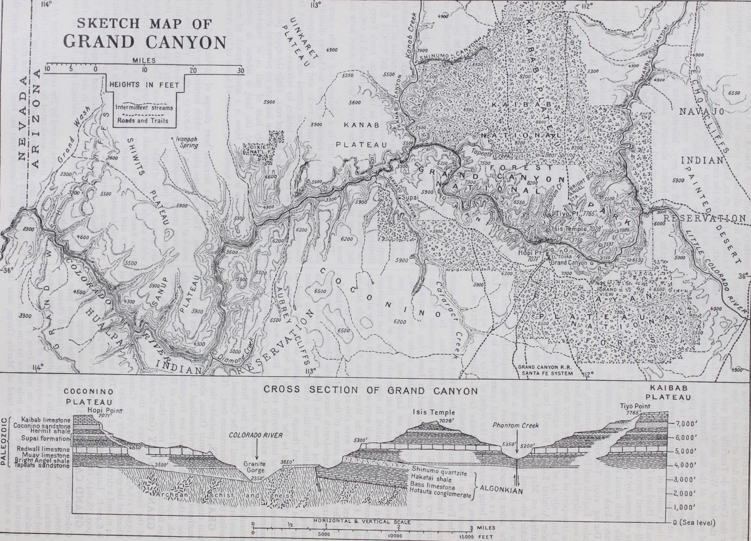
GRAND CANYON, THE, an immense gorge cut by the Colorado river into the high plateau in the northern part of Arizona, U.S.A. It is a broad, intricately sculptured chasm that contains between its outer walls a multitude of imposing peaks and buttes, of canyons within a canyon and of complex ramifying gulches and ravines. It ranges in width from 4 to 18 m., its greatest depths lie more than a mile below its rim and it extends in a winding course from the head of Marble Gorge, near the northern boundary of Arizona, to Grand Wash Cliffs, near the Nevada line, a distance of about 28o miles. Its most impressively beautiful part, 56 m. long, lies within the Grand Canyon National Park. Through it the river winds for 105 miles.
In its general colour the canyon is a dull red that glows when lit by the sun, but it displays the parallel edges of beds of many-coloured rocks, whose varied tints give it wonderful di versity—pale buff and grey, delicate green and pink, and, in its depths, chocolate-brown, slate-grey and other sombre hues. Its distances are often suffused with a transparent blue-purple haze that contrasts with the deep green of the pine trees on its rim and the intense blue of the sky.
The first white man to behold the Grand Canyon was Garcia Lopez de Cardenas, who had been sent from Zuni, New Mexico, to find a river far to the west, the existence of which had been learned from the natives. In 1854 Lieut. A. W. Whipple fol lowed the lower course of the Colorado river as far up as the mouth of Diamond creek. In 1857 Lieut. J. C. Ives travelled through the gorge of Diamond creek and eastward to Havasu canyon, the San Francisco mountains, the Little Colorado and the country of the Hopi Indians.
The first graphic and geological description of the Grand Can yon was given by Prof. John S. Newberry. It remained for Maj. John W. Powell to make the first voyage through the depths of the canyon. He embarked in May 1869 at the bridge of the Union Pacific railroad over the Green river, in Wyoming, with nine companions, in four small rowboats. After a perilous trip through turbulent rapids, covering three months, during which four of his men deserted, he emerged safely from the lower end of the canyon. He put an end to many myths, including one about an underground "lost course" of the river.
In 187o, under the auspices of the Smithsonian Institution, Powell set out to explore the Colorado more thoroughly. For several years he carried on geographic, geologic and ethnologic studies in the region, and supervised the preparation of the first map of it. In 1923 a Government expedition led by Col. C. H. Birdseye, descended the Colorado in boats from Lee's Ferry to the mouth of the canyon to find sites for dams and to complete the survey of the profile of the river. Accurate maps have now been prepared.
The Grand Canyon is cut in a plateau that stands 5,000 to 9,00o ft. above sea-level, a region of mesas and buttes diversified by lava flows, masses of intrusive rocks and hills composed of volcanic ash. The plateau slopes in general south-westward, but the continuity of its surface is broken by terraces that represent either folds or faults in the beds of rock. Only the upper plateaus are covered with forests, but even here are no perennial streams. The rock slopes are generally bare of soil or of vegetation. In the bottom of the canyon the heat is intense in summer and frost is rare in winter. Here is a sparse growth of desert bushes and cacti, of Spanish bayonet and of agave or "the century plant." Parts of upper terraces bear clumps of juniper and gnarled pinon. The Coconino plateau, which borders the canyon on the south at altitudes ranging from 6.000 to 7,00o ft. above sea-level, receives enough precipitation in snow and showers to sustain an open forest of juniper and pinon, and on its higher parts there are groves of tall, straight yellow pines. The Kaibab plateau, which stands on the north side of the canyon, at altitudes ranging from 8,000 to 9,00o ft. above sea-level, has a mountain climate, snowy and severe in winter, agreeably cool in summer. It bears majestic forests of yellow pine, with which is mixed some Engle mann spruce. Scrub oak and cottonwood grow in the bottoms of the shallow dry washes on the plateau and clumps of aspen line the grassy glades and natural "parks" in the valleys, where thou sands of deer and, outside of the national park, herds of cattle find grazing ground.
The Grand Canyon was formed by the ceaseless cutting of the silt-laden Colorado river, accelerated by storm waters that oc casionally fall into the Canyon, and by "weathering" processes. The most effective of these agencies has been the river.
Although the Colorado river has been the principal agent that formed the Grand Canyon, it has not directly carved the canyon to its full width; neither has it cut the embayments that scallop the rims of the plateaux. It has cut its way vertically downward, maintaining its course almost without change. Meanwhile the rocky walls of the canyon have been exposed to destruction by the action of rain and rill, of frost and landslide, of wind and chemical action.

The south rim of the canyon is nearer to the river than the north rim, and the erosion on the north side of the river is much greater than on the south side. This difference is due to several causes, which, named in the inverse order of their effectiveness, are as follow: (I) As the land in the plateau region slopes south westward, at a right angle to the general course of the river, the streams of the Kaibab plateau, on the north, drain into the canyon, whereas those of the Coconino plateau, on the south, drain away from it; (2) the beds of rock in the region also slope toward the south-west, so that the underground water coming from the north, beneath the Kaibab plateau, flows into the canyon, whereas that going southward, beneath the Coconino plateau, flows away from it; (3) the north rim of the canyon is I 000 ft. higher than south rim, and the streams that flow down it and the rainwater that falls on it make a longer descent and do correspondingly more erosional work; (4) fractures and faults by which the beds of rock have been so greatly broken that pieces of them have been easily removed by erosion are more numerous on the north side than on the south side. These fractures and faults have deter mined the course of some of the streams in the canyon. The intricate sculpture of the broad north side of the canyon, which is its most spectacular part, was thus determined in part by the network of fractures and faults in its rocks.
While the river has been cutting its way downward the land in the plateau region has been gradually rising, and both the up lift of the land and the carving of the canyon are events of recent geologic history. The Grand Canyon is a relatively new geologic feature, even though the work of making it has been carried on for more than a million years. Although the canyon is new, the beds of rock exposed in it are old ; they tell a story that began many millions of years ago. Most of the geologic forma tions in the canyon are sedimentary—that is, were laid down in water—but the Coconino sandstone, which underlies the Kaibab limestone, the uppermost formation exposed in the walls of the canyon, appears to be in part, at least, a deposit of wind-blown sand, a sort of fossil desert. At some places volcanic rock is seen. The rock that lies below the sedimentary series is the Vishnu schist, which is greatly squeezed and crumpled and into which were injected, at some places, molten masses of igneous rock that formed dikes and sills. The red Supai formation, which underlies the Coconino sandstone and which forms the wall of the part of the canyon in which the Supai Indians live, imparts the colouring matter of its shaly beds to the underlying Redwall limestone, a hard rock which is in itself pale blue and which forms steep cliffs that can be easily traced through the canyon. At the foot of the Redwall begin the slopes of the light-buff Muav limestone and the greenish Bright Angel shale, which lead down for 70o ft. to the broadest and lowest terrace of all, the Tonto platform.
The Grand Canyon National Park, which was created by the United States Congress in 1919, embraces I,0o9 sq.m. The most prominent of the rock masses within the canyon have been called "temples," because of their resemblance to Oriental temples of worship—the pagodas of Asia. These temples are carved from blocks of essentially horizontal strata, and some of them rise more than a mile above the level of the river and carry at their tops remnants of the bed that forms the surface of the plateau. The great chasm contains towers, buttes, terraces, platforms, am phitheatres and other striking features to which distinctive names have been given. Some of the formations contain traces of ancient lif e—impressions of seaweeds and of other plants long extinct, the remains of corals and marine shells and of extinct forms of fishes, as well as tracks of animals. The Grand Canyon is therefore not only a remarkable example of earth sculpture produced by erosion but is of immense scientific interest because it discloses a great perspective of the geologic past.
By motor car the south rim of the Grand Canyon may b.e reached via U. S. Highway 66, about 6o miles south. From Wil liams, Arizona, State Highway 64 leads directly to the south rim. Motorists may leave U. S. Highway 66 at Flagstaff, proceed north until near Cameron, and then go west to Desert View on the south rim. By rail the south rim may be reached on a branch line of the Santa Fe System from Williams, Arizona. From Cedar City, Utah on U. S. Highway 91, motorists for the north rim continue to the town of Mount Carmel, where connection is made with U. S. Highway 89 for the trip south. By rail the approach is via the Union Pacific System from Lund, Utah; from there in buses. A pack horse route down the Bright Angel trail across the river on a suspension bridge and up Bright Angel canyon connects the southern and northern rims.
Grand-duke is also the conventional English equivalent of the Russian velikiy knyaz, more properly "grand-prince" (Ger. Gross fiirst), at one time the title of the rulers of Russia, who, as the eldest born of the house of Rurik, exercised overlordship over the udyelniye knyazi or local princes. On the partition of the inherit ance of Rurik, the eldest of each branch assumed the title of grand-prince. Until 1886 this title grand-duke or grand-duchess, with the style "Imperial Highness," was borne by all descendants of the imperial house. It was then confined to the sons and daughters, brothers and sisters and male grandchildren of the emperor. The other members of the imperial house bore the title of prince (knyaz) and princess (knyaginya if married, knyazhna if unmarried) with the style of "Highness." The emperor of Austria, as king of Hungary, also bore this title as "grand-duke" of Transylvania, which was erected into a "grand-princedom" (Grossfurstentum) in 1765 by Maria Theresa.