
GREAT LAKES, THE. The Great Lakes and their connect ing waterways are in general along the boundary between the United States and Canada between 75° and 92° W. of Greenwich. In 1909 the United States and Great Britain signed a treaty known as the "Boundary Waters Treaty," whereby the waters between the United States and Canada were guaranteed free and open to the inhabitants of both countries on equal terms, and principles gov erning the use of boundary waters were laid down. An interna tional joint commission consisting of three members from Canada and three members from the United States was established. Neither the United States nor Canada has found it necessary or desirable to organize any defences on the boundary between the two countries or maintain ships of war in the Great Lakes for over years. The channels in the connecting waterways and the sailing courses in the open lakes cross and recross the interna tional boundary many times.
The Great Lakes and their connecting waterways are the most important unit of inland waterway transportation in the world, and have been of great economic importance in the development of the North American continent. Their drainage basin has an area of about 300,00o sq.m., approximately 6o% lying within the United States. The water surface of the lakes and rivers themselves covers 96,00o square miles. The total distance, measured along the steamer track from Duluth to the outlet of Lake Ontario, is 1,160 miles. Their outlet to the Atlantic ocean is through the St. Lawrence river.
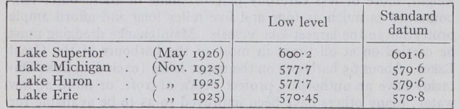
Dimensions, elevations and other descriptive details of each of the lakes and connecting waterways are given in the following table, the data being derived from the bulletin and charts of the U.S. Lake Survey : mainder in vessels of the United States. Traffic through the De troit river in 1926 amounted to 95,003,604 tons, valued at $1,179, 944,762. Package freight has not developed in anything like the same proportions as has bulk freight, the total on the lakes aver aging about 2,500,00o tons per annum.

About 3o important passenger lines are in regular operation upon the Upper Great Lakes, exclusive of the companies operating day-excursion boats and passenger ferries. Most of these lines operate only during the navigation season, although in certain in stances, notably in the case of the Pere Marquette Line steamers which operate across Lake Michigan, passenger service is main tained throughout the year. Several of the lines offer especially good passenger accommodations and attractive long-distance s cruises. Other lines operating between important cities, notably those running between Detroit, Cleveland and Buffalo, in overnight construction of this canal was commenced in 1913. It was largely In the past more than 9o% of the freight movement of the Great service, carry a heavy passenger traffic in luxurious boats, some of which are of exceptionally large size. Two of the latest passenger steamers, the "Greater Detroit" and "Greater Buffalo," are said to be the largest inland waterway passenger steamers in the world. They are steel vessels of the side-wheel type, 55oft. length overall; width, over guards, roof t. ; draft, 16f t. ; speed, 21 statute miles per hour. Sleeping accommodations are provided for 1,200 passengers. These boats are in operation between Detroit and Buffalo. Pas senger steamers usually have accommodations for automobiles and for a limited amount of express freight.
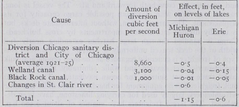
The effect of the present diversions and outlet changes is esti mated as follows : Upon the opening of the new Welland ship canal the lowering of Lake Erie, due to increased diversion for navigation purposes, will be increased to 0.7 foot. Any additional deepening of channels in St. Clair river will further lower the levels of Lakes Huron and Michigan.
A dike on which sluice gates are installed has been con structed across the St. Mary's river near Sault Ste. Marie. The gates are operated under the supervision of an international board of control in order to maintain water-levels in Lake Superior and to compensate for diversions on both the Canadian and the American sides at Sault Ste. Marie for power purposes.
The construction of compensating works in the Niagara and St. Clair rivers, designed to raise the level of Lake Erie by 0.7 foot and of Lakes Huron and Michigan by one foot, have been recom mended by a joint board of engineers appointed by the Canadian and U.S. Governments. The locks include a series of submerged rock sills in St. Clair river with crests 3 I f t. below datum, and a timber crib dike, stone weir and submerged rock sills in the Niagara river.
The question of diversion of water from Lake Michigan into the Chicago drainage canal for the purpose of sewage disposal has not been settled. The Supreme Court of the United States decided against the Chicago drainage district in a suit instituted to enjoin the district against withdrawing water. However, in order to permit the Chicago sanitary commission to prepare plans and construct works necessary to take the place of the prevailing sys tem of sewage disposal, temporary authority to divert 8,50o cu.ft. of water per second from Lake Michigan was granted by the U.S. War Department for a period of five years under certain condi tions, which, when carried out, will permit the reduction and per haps the eventual discontinuance of the diversion for sewage pur poses. The question is of importance because of the enormous losses claimed by shipping interests on account of lower water levels. The matter is again before the Supreme Court of the United States as a result of an action brought by some of the States to restrain the Chicago drainage district from diverting water from Lake Michigan. The report to the court made by former chief justice, Chas. E. Hughes, who was designated as special master, was to the effect that the permit granted by the War Department is valid and effective according to its terms. Final decision in the matter has not been made.
The New York State barge canal has replaced the old Erie canal. It connects with the Great Lakes at Tonawanda on Niagara river, and at Oswego on Lake Ontario. The present 12f t. depth of canal is designed for use by barges and boats drawing 'al feet.
The St. Lawrence river from its source at the outlet of Lake Ontario to the Atlantic at Belle Isle strait is 1,184m. in length. For purposes of navigation the river may be considered in three portions: the broad estuary below Father Point, 661 m. in length; the section 34 2m. in length from Father Point to Montreal which has been improved for navigation by ocean vessels; and the sec tion 181 m. in length between Montreal and Lake Ontario, in which there is a fall of approximately 2 2 5 f t., and which has been canalized at all rapids and is available for small vessels of 14ft. draft. The problem of providing a channel through the St. Law rence for ocean shipping is now the subject of negotiation between the Canadian and U.S. Governments. (See ST. LAWRENCE RIVER.) By treaty stipulation the amount of water that may be diverted from the Niagara river for power purposes has been limited to 36,00o cu.ft. per sec. on the Canadian side and 20,000 cu.ft. per sec. on the United States side. Of the Canadian diversion all but about I o,000 cu.ft. per sec. is used by the Hydro-electric Power Commission of Ontario in three plants, the largest of which, near Queenstown, has a gross head of over 3oof t. and develops about 450,00o h.p. from the nine turbo-generators installed. Of the American diversion practically all the water is utilized by one concern with an installation of 56o,000 horse-power. Three of the units of the latter company are rated at 70,00o h.p. each and are the largest hydro-electric units in existence. At all the plants, electricity is generated at 11,00o volts, 25 cycles. Much is used in nearby electro-chemical industries for the manufacture of aluminium, ferro-silicon, carborundum, artificial graphite, liquid chlorine, calcium carbide, cyanamide and other products. The remainder is transmitted to various cities for miscellaneous uses. The maximum distance to which this power is transmitted is somewhat in excess of 200 miles.
BIBLIOGRAPHY.--Annual Report, chief of engineers, U.S. army; Bibliography.--Annual Report, chief of engineers, U.S. army; Charts and Bulletins of the Lake Survey ; Transportation on the Great Lakes, U.S. Government printing office (1926) ; Report of Interna tional Joint Board of Engineers, U.S. Government printing office (1927) ; Document No. 288, 69th U.S. Congress, ist Session; Annual Report, Lake Carriers' Association ; Great Lakes Commerce, by Fay, Spofford and Thorndyke, consulting engineers. (E. JA.)