
BURMA, though formerly a province of the Indian empire, is geographically a part of Indo-China, and is frequently called by the French "Indo-Chine anglaise." The province of Burma, as constituted since the annexation of Upper Burma in 1886, comprises the British territory of Upper and Lower Burma, the extensive native States known as the Federated Shan States, and Karenni, as well as several tracts of unadministered territory in the more remote parts. Lower Burma corresponds to the area acquired by the British Indian Government in the two wars of 1826 and 1852, while Upper Burma is the former independent kingdom of Burma, annexed on Jan. 1, 1886. The province stretches from 9° 55' to about 28° 3o' N. and from long. 92° 1o' to Io I ° 9' E. The extreme length from north to south is almost 1,200m. and the broadest part, which is in about lat. 21° N., is 575m. from east to west. The total area is estimated at 262,732 sq. miles. Burma proper, inclusive of the Chin hills and the ad ministered Kachin hill tracts, occupies about 184,102 sq.m., the Shan States, which comprise the whole of the eastern portion of the province, some 62,305 sq.m., and the unadministered territory some 16,325 sq. miles. Thus the province of Burma is the largest of the provinces of India.
Roughly half of Burma lies outside the Tropics, but the con figuration of the country is such that the whole may be regarded as a tropical country. In the north the boundary between Burma, Tibet and China, has not yet been precisely determined. The north-western frontier touches Assam, the dependent State of Manipur, and those portions of Bengal included in the Lushai hills and Chittagong. On the west the boundary is formed by the Bay of Bengal, in the south-west by the Gulf of Martaban. On the east the frontier touches the Chinese province of Yunnan, the Chinese Shan and Lao States, French Indo-China and Siam. In the south the boundary is formed by the Pakchan river.
falls nat urally into three great geomorphological units : (a) The Arakan Yoma, a great series of fold ranges of Alpine age, which forms the barrier between Burma and India. The foothills of the Arakan Yoma stretch as far as the shores of the Bay of Bengal. (b) The Shan plateau massif, occupying the whole of the east of the country and ex tending southwards into Tenasserim. The massif forms part of what has been called the Indo-Malayan mountain system and has existed as a geomorphological unit since the close of the Mesozoic. (c) The Central basin, lying between the Arakan Yoma and the Shan plateau. Formerly a gulf of the early Tertiary sea, open to the south, it is now occupied by a great spread of Tertiary rocks.
The great mountain range of the Arakan Yoma and its continuation northwards has a core of old crystalline rocks. On either side are hard, folded sedimentary rocks, mainly Tertiary in age. Rocks of Jurassic and Cretaceous age are also known to occur, but the geology of the ranges is still very imperfectly known. Extensive strike faulting occurs along the eastern flanks of the Arakan Yoma and large serpentine intrusions, probably of Cretaceous age, are associated with the faults. Chromite and other useful minerals are known to occur, especially in association with the serpentine, but are not at present exploited. The western edge of the Shan plateau massif is well marked both physically and geologically. It rises abruptly from the valley, and for 400 or 5oom. the edge is formed by a long strip of granitic or gneissose rocks. The predominant rocks in the Shan plateau are gneisses—which yield the rubies and other gems for which Burma has so long been famous—and a massive limestone of Devono-carboniferous age. Rocks of all ages from pre-Cambrian to Jurassic occur in the massif, whilst de posits of late Tertiary and Pleistocene age occupy old lake-basins. In pre-Cambrian rocks at Mogok occur the principal ruby "mines," —but the industry is now of minor importance. At Bawdwin, associated with a group of ancient volcanic rocks, are very exten sive deposits of silver-lead ore, mainly argentiferous galena, which are worked by the Burma Corporation, Ltd., and smelted at the nearby works of Namtu. The refined silver and lead are sent by rail to Rangoon for export. Other silver-lead deposits are known in other parts of the Shan States, and have been worked in the past by the Chinese. Tenasserim forms a continuation of the tin bearing belt of Malaya, and large quantities of tin and tungsten are obtained. Geologically this portion of the Indo-Ma.layan moun tains consists of large granitic intrusions, elongated in the north south direction and intruded into a series of ancient rocks of un known age. The basin of the Irrawaddy between the Arakan Yoma and the Shan plateau, consists almost entirely of Tertiary rocks. The beds are remarkable for their enormous thickness ; the Eocene beds reach upwards of r 5,000f t. ; the Peguan (Oligo Miocene) upwards of i 6,000f t., and the Irrawaddian (Mid Pliocene) upwards of 5,000 feet. Forming a line down the centre of the basin are the well known oilfields of Burma. The oil occurs mainly in rocks of Peguan age. From north to south are the fields of Indaw, Yenangyat, Singu, Yenangyaung, Minbu and several minor fields. The most important fields are Yenangyaung and Singu. Brown coal also occurs in considerable quantities in the valley of the Chindwin and elsewhere in the Tertiary rocks, but as yet has been little used. Along a line running, roughly, along the centre of the ancient Tertiary trough, are numerous extinct volcanoes; some form small tuff cones with small crater lakes; others are plugs of rhyolitic matter, but the largest is the com plex cone of Mt. Popa.
Between the Arakan Yoma on the west and the Shan plateau on the east, lie the basin of the Irrawaddy and its great tributary, the Chindwin, and the basin of the smaller Sittang. This is for the most part a lowland area, with ranges of hills—of which the Pegu Yoma is the most important—running from north to south. Almost in the centre the extinct volcano of Mt. Popa reaches nearly 5,000f t. above sea-level. The Arakan coast of Burma is Pacific in type, it is rocky and dangerous, backed by high moun tains and fringed by islands. Of the islands, Ramree and Cheduba are the largest. The Tenasserim coast is similar; in the south is the Mergui archipelago. Between the Arakan and Tenasserim coasts lies the low delta of the Irrawaddy and Sittang rivers.
Most of the hilly and mountainous regions were formerly forest covered, and over large areas have good, fertile forest soils. Where clearings have been made, temporary cultivation has de stroyed the virgin richness of the soil. In the wetter regions the heavy rains often entirely wash away the soil from cleared hill sides and expose the bare rock. The limestone rocks of the Shan plateau are usually covered by a thin red soil from which the lime has been entirely leached out. The richest soils in the province are the alluvial soils of the flat Irrawaddy delta and the broad river valleys. Excellent loamy soil is also afforded by the mixed clays and sands of the Peguan rocks, but the Irrawaddian and other sandy series give rise to extensive tracts of very light soil, almost pure sand. In the wetter parts of Burma, owing to the well marked dry season, a thick mantle of lateritic soil stretches over most of the lowland tracts.
From October to May Burma is under the influence of the north-east trade wind or the north-east monsoon as it is more often called. The north and south alignment of the mountains causes this wind to blow almost directly from the north. It is a cool wind, but decreases in intensity towards the end of the dry season. The change to the south-west monsoon is heralded by thunderstorms towards the end of May, but the rains do not usually break until about June 15. The south-west monsoon, blowing as it does from the Indian ocean, is the rain-bearing wind. A glance at a physical map will show that the coastal districts receive the full force of the wind, and a heavy rainfall in conse quence. Most of Arakan has nearly 2ooin. (5,i 2omm.) of rain. Rangoon enjoys an annual fall of 99.1 in. (2, 53 i mm.) . The heart of Burma lies in the lee of the lofty Arakan Yoma and the rainfall is scanty—as little as coin. in the heart of the dry belt. Mandalay lies in this dry region and receives an average of 33.4in. (855mm.). Owing to its elevation, the Shan plateau has a mod erately good rainfall.
The largest lake in Burma is a shallow stretch of water in the Federated Shan States, known as Inle lake. It is the remnant of a much larger lake ; is rapidly becoming smaller, and occupies a hollow in the surface of the plateau. A large lake known as Indawgyi, is found in the north of Burma near Mogaung. It has an area of nearly ioo sq.m. and, with the decreasing size of Inle lake, should perhaps be given pride of place. It is surrounded on three sides by ranges of hills, but is open to the north where it has an outlet in the Indaw river. In all the lowland tracts there are numerous small lakes occupying deserted river meanders. In the heart of the delta numerous large lakes or marshes, abound ing in fish, are formed by the overflow of the Irrawaddy river during the rainy season, but decrease in the dry season.
The wasteful methods of the native cultivator have, in the past, resulted in the destruction of vast areas of valuable forest. The practice was to cut down and burn a tract of virgin forest, cultivate the field (taung-ya) so formed for two or three years while the pristine freshness of the soil lasted and then to desert it for a fresh tract. It is but rarely that the forest established itself again over the deserted taung-ya ; more often the area became covered with a tangled mass of bamboo, bracken or grass. For more than half a century, however, the Forest Department has been at work, and all the valuable forests are constituted into Government reserves. Reserves covered 28,372 sq.m. in 1926. Various privileges are accorded to the natives who live within the reserved area. The timber (mainly teak for constructional work and pyinkado—Xylia dolabri f ormis—f or railway sleepers) , is worked either by Government or by lessees--public and private companies—under careful supervision. Extraction is so controlled that it shall not exceed regeneration. The output of teak in 1925-26 was 339,526 tons, and of other reserved timbers 163,318 tons. Timber is third in importance amongst the exports of Burma, and for some years past the annual exports have been roughly 150,000 tons annually; worth about Łr,5oo,000. More than half Burma is forested.
Burma is essentially a rural country. Only two towns have over 1oo,000 inhabitants—Rangoon with 341,962, and Mandalay with 148,917. The smaller towns are river ports, collecting and distributing centres, or have achieved some importance from having been chosen as the headquarters of a district. The dry belt is the natural geographical centre of Burma and therein lie the old Burmese capitals—Pagan, Shwebo, Ava, Amarapura and Mandalay, with Prome on the southern borders of the dry belt.

The inhabitants of Burma belong to many races and speak many languages. In general, the native races are all Mongolians; the Burmans are the most advanced, and occupy the fertile low lands; the other races are restricted to the hills. Every year large numbers of Indians are attracted to Burma by the higher rates of wages, and the opportunities for trading and cultivation. A considerable proportion of the Indian immigrants settle per manently. Burma is in the interesting position of being an under populated country, capable of considerable development, lying between two of the most densely populated countries in the world --*India and China. It is believed that Burma has been populated by successive waves of migration from the north ; indeed the advance of the Kachin races was still in progress when Burma was annexed to the British empire. The Burmans, including the closely allied Arakanese of the Arakan coast, the Talaings of the country around Moulmein, and the Tavoyans around Tavoy, number more than r I millions. The national dress is a cylin drical skirt, called a lungyi, worn folded over in a simple fold in the front and reaching to the ankles. All Burmese, of both sexes, prefer silks of bright but delicate shades, and even the poorest possesses at least one silk lungyi. The distinctive silk, woven in the district round Mandalay, is still in general use. The lungyi is worn by both sexes, the men wear also a single breasted short jacket of sombre hue, called an aingyi; the women's garment is similar but double breasted and usually white. The older generation of Burmese men wear their straight black hair long, tied in a knot on one side of the head. It is now general to cut the hair in European style. The men's head-dress is a gambaung —a strip of brightly-coloured thin silk wound round the head. The women oil their long tresses with coconut oil and coil them in a cylindrical coil on the top of the head.
The Burmans are Buddhists, and their religion occupies a large place in their life. The spiritual head of every village is the yellow-robed Hpoongyi, or monk. The monastery, or hpoongyi kyaung just outside the village walls—all Burmese villages are surrounded by a fence against wild animals and robbers—is also the village school. Every village has its pagoda, a silent remainder of the precepts of Buddha, and the whitewashed pagodas crown almost every hill, but there are no temples in the ordinary sense of the word. As a result of the numerous village schools, the per centage of wholly illiterate men is small. The women are more industrious and business-like than the men, but their school educa tion has been neglected. The Burmese women enjoy an amount of freedom unusual in non-European races. As a whole the Burmese are characterized by cleanliness, a sense of honour and a love of sport, but addicted to a life of ease and laziness. The various hill tribes are, in general, less advanced than the Burmese. Per haps the most advanced are the Karens, who inhabit the Arakan Yoma, the Pegu Yoma and the native State of Karenni, and are also found as scattered communities in the delta. The Shans occupy most of the Shan plateau and are also found in the upper part of the Chindwin valley. The Kachins belong mainly to the far north, the Chins to the western mountains, whilst on the Chinese borders are found the Palaungs, Was, etc. Some of the latter are still addicted to the barbarous practice of head hunting. All the hill tribes of Burma are non-Buddhists, being for the most part Animists. Christianity has made rapid strides amongst them, especially amongst the Karens.
The Indians have settled mainly in the delta regions, in Arakan and along the rivers and railway lines. Except in the remoter districts, Indians supply nearly all the coolie labour, whilst the indolent habits of the Burman often result in his falling into the clutches of the Indian moneylender. There are now roughly a million Indians in Burma, drawn mainly from Madras, Behar and Orissa and Bengal. The Chinese form an important community. Except on the border in the north-east, where the Yun nanese and Chinese Shans are found, the Chinese belong essentially to the artisan and merchant classes, and make excellent law-abiding citizens.
Europeans, mainly English and Scotch, number rather less than 1 o,000 ; very few can be regarded as permanent residents.
Eurasians (now officially termed Anglo Indians) number about ro,000. The Eura sians find employment as clerks in minor administrative capacities, and on the rail ways.
The Burmese language is a monosyllabic, agglutinative language, more closely allied to Chinese than to the Indian languages. A single syllable may have six or more meanings, according to the tone used or to the way in which the syllable is stressed. Many dialects and languages belonging to the Burmese group are dis tinguished, quite apart from the entirely distinct languages spoken by the Shans, Kachins, Karens and other hill tribes. Burmese and English are the official languages. Hindustani is widely spoken wherever Indian labour is employed.
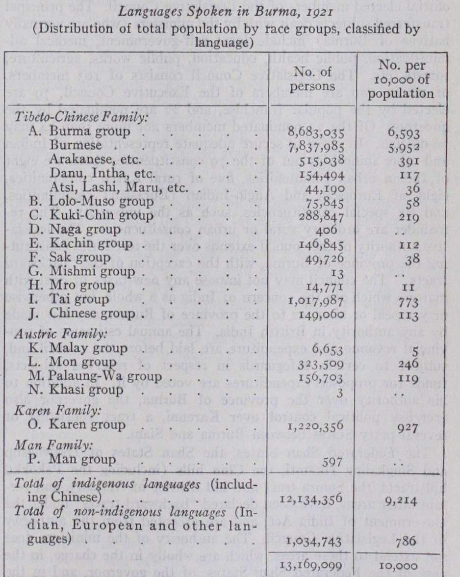
Note: There is an increasing tendency for Burmese to become the language of people belonging racially to such groups as Kuki-Chin, Kachin and Tai.
The Burmans adopted alphabets borrowed from the old, rock cut Pali of India. Thus their alphabet, their religion and a con siderable number of words, are of Indian origin. Burmese music is distinctive; their melodies are mainly composed of the five notes, C, D, E, G, A ; they do not use semitones, so the chro matic scale is unknown. Music is essentially associated with the drama. Characteristic instruments include the kyi-waing, a series of gongs cast out of bell metal, arranged in a circular frame of stout cane and the saing-waing, composed of 18 cylindrical drums hung from a circular frame.
The Federated Shan States, the Shan States of Hsawngsup and Singkaling Hkamti, the Chin hills (including the Pakokku hill tracts, the Somra tract and hill district of Arakan), and cer tain other areas, have been declared "backward tracts" under the Government of India Act, and are excepted from the authority of the Legislative Council. The authority of the ministers does not extend to these areas, which are wholly in the charge, in the case of the Federated Shan States, of the governor, and in the case of the "backward tracts," of the governor in council. A special personnel for the administration of the "backward tracts" is pro vided by the Burma Frontier Service.
The province is at present divided into eight divisions, each in charge of a commissioner, they are Arakan, Pegu, Irrawaddy, Tenasserim, Magwe, Mandalay, Sagaing and the Federated Shan States. The commissioners are responsible to the governor in council, each in his own division, for the working of every de partment of the public service except the military department and part of the judicial department. The divisions are further divided into districts (of which there are about 4o) each in charge of a deputy commissioner. Deputy commissioners perform the func tions of district magistrates, collectors, registrars and sometimes of assistant commissioners of income tax and district judges. Subordinate to the deputy commissioners are assistant commis sioners, extra assistant commissioners and myooks. The myooks or township officers are drawn from the ranks of the subordinate civil service and are the ultimate salaried representatives of Government who come into most direct contact with the people. The extra assistant commissioners are members of the Burma Civil Service; higher officials are members of the Burma Com mission and are mostly officers of the Indian Civil Service. Finally there are the village headmen or thugyis,, chosen by the villagers and approved by Government, who have limited magisterial powers and collect the thathmeda or head tax.
The land and revenue administration of the province is con trolled by a financial commissioner assisted by a secretary. Under the control of the financial commissioner are the Excise Depart ment (dealing with opium and salt), customs, settlements and land records. The High Court of Judicature at Rangoon was estab lished in 1922. It consists of a chief justice and seven other judges. In 1925 the Province was divided into 23 session divi sions. The activities of the Government in connection with agri cultural and industrial development are under the control of a development commissioner, subordinate to whom are the Depart ment of Agriculture, the Rangoon Development Trust, the co operative societies registrar and the veterinary adviser. The Public Works Department is under the control of chief engineers for buildings, roads and irrigation. The Police Department is under the control of an inspector-general; the military police (used mainly in frontier tracts) are under a deputy inspector general. The Forest Department is administered by a chief con servator of forests and the province is divided into a number of "circles," each under a conservator, assisted by officers of the Indian, provincial and subordinate forest services. (For details regarding the administration of the Federated Shan States see