
IDAHO, the "Gem State," one of the far north-western States of the U.S., is situated between 42° and 49° N. and III ° and I I 7 ° W. It is bounded on the north by British Columbia in the Dominion of Canada, on the east by Montana and Wyoming, on the south by Utah and Nevada, and on the west by Oregon and Washington. Its area, of which 534sq.m. are water surface, is 83,88osq.m., or 53,346,56oac. This is about the size of England and Scotland combined, or of New England plus New Jersey. The name is an expression of the Shoshonee Indians, Ee-dah-how, meaning, "Look, the sun is coming down the mountain!" It was used by the Indians to arouse the camp in the morning. The popular name "Gem State" is derived from the expression "gem of the mountain," often erroneously given as a translation of the Indian name.
Bordering the Snake river in a belt 5o to 75m. wide are the Snake river plains, originally arid, desolate sage-brush land, but now irrigated and Idaho's chief agricultural region. These plains were built up by a series of lava sheets from extinct volcanic craters to the north, and the volcanic-ash soil is rich in mineral elements of plant food, such as phosphorous and potash. In the northern plain between Arco and Carey is a district containing about 63 volcanic craters, lava and cinder cones, which was set apart in 1924 as the "Craters of the Moon" national monument. It is a region with weird landscape effects and furnishes the best example of fissure lava flows in North America. South of the plains the land rises to a divide between the Columbia basin and the Great Salt Lake basin. This divide in places breaks into low mountain ranges. In the south-east the Bear river range forms a northern extension of the Wasatch range of Utah. In the south west the Owyhee mountains and their foothills occupy a large area.
The main mountain system of the State, however, is formed by those ranges (the Cabinet, Coeur d'Alene, Bitter Root and Beaverhead) which lie along the north-east boundary, together with their various spurs extending westward and south-westward toward the central part of the State. From these mountains flow the Salmon and Clearwater rivers, the ,main branches of the Snake. Through narrow valleys and canyons often impassable, they drain the most thinly settled and the wildest and most rugged section of the State. Most of the region, an area several times larger than Switzerland, is still impenetrable except by pack-horse. Its existence has prevented the construction of a railway connecting north and south Idaho, and not until 1927 was a north and south highway completed. All travel previously between the two settled regions of the State had to pass through Oregon and Washington. The wilderness region is bounded on the south by the Sawtooth mountains, a range which also forms the northern boundary of the Snake river valley. These moun tains rival in sublimity any range in the United States. They contain Hyndman peak (12,o78ft.), the highest point in Idaho. Other high and beautiful ranges of the region are the Salmon river mountains and the Lost river range. South of the latter are Big Lost river and a number of smaller streams which disappear after reaching the upper Snake river plains in the driest portion of Idaho. North of the Salmon river country is the Clearwater country, through which runs the Lo Lo trail travelled by Lewis and Clark. This trail passes through the largest area of virgin timber still standing in the United States. The whole region fur nishes excellent hunting of the white-tail and mule deer, elk, bear, mountain goat and blue and ruffed grouse and other game birds. The State game warden reports deer and moose to be increasing. Beautiful mountain lakes abound in fish and furnish enchanting camping sites. The region is also rich in mineral resources, which must wait for transportation facilities before they can be profitably developed.
The northern part of the State is low (average 3,000ft.) com pared with the average level of the State (5,000f t.) , and this low altitude gives it an advantage in climate which offsets its northern position. There are ranges of great height and beauty, but the valleys between are broad and fertile. Towards the Wash ington boundary in particular, there are many fine farming regions. An abundant rainfall in this northern section (20 to 35 in. annually) makes irrigation unnecessary. Here are the largest and most beautiful of Idaho's lakes—Priest lake, Pend Oreille and Coeur d'Alene. Across this narrow northern portion flow the Clark Fork and Kootenai rivers on their way to join the Colum bia. The lowest portion of the State is at Lewiston, where the Snake river leaves the State at an altitude of only 72oft.

The vast extent and varied topography of Idaho give it a number of distinct climate zones. The entire State comes under the modifying influence of the equable climate of the North Pacific ocean and is protected by its great north-eastern mountain barrier from the severe cold waves that sweep the plains east of the continental divide. The mean annual temperature varies from about 36° (coldest region centring in Custer county, around the Sawtooth range) to 55° along the middle reaches of the Snake river. In the lower valleys of the Snake and its tributaries the weather is mild enough for even the more tender fruits. The orchards of this region are becoming famous. Precipitation varies even more than temperature, but in general it is greatest in the mountainous region and least in the open plains. The driest regions are along the great south-west bend of the Snake, in the Lost River country, and in the upper reaches of the Salmon river. Tornadoes and severe storms are virtually unknown.
The executive department is made up of elected and appointed officers, all serving two years. Those elected are the governor, lieutenant governor, secretary of State, State auditor, State treasurer, attorney general, superintendent of public instruction, and inspector of mines. In addition to the usual duties of their offices, these officers serve on the State library commission and on special administrative boards, such as the board of pardons, the board of land commissioners, the board of equalization, the board of canvassers and the board of examiners. In 1919 an act of the legislature grouped 51 bureaus, boards and commissions into nine departments. Later the nine departments were reduced to seven: the departments of agriculture, finance, law enforcement, public investments, public welfare, public works and reclamation. Each department is headed by a commissioner appointed by the gov ernor and responsible directly to him.
The legislature consists of two houses, whose members are elected biennially. A senator is elected from each county, and a representative for every 2,500 votes or fraction thereof exceeding 1,000 in each county. In 1937 there were 44 senators and 59 representatives. The legislature meets at Boise for its regular session the first Monday of January in odd-numbered years. Special sessions may be called by the governor if he decides that they are necessary. A two-thirds vote of the legislature can over ride the governor's vote.
The judiciary consists of a supreme court, holding five terms yearly, its five justices being elected for six years, and 11 district courts with 16 judges, each holding office for four years. At least two terms of the district court must be held in each county each year. Each county also has a probate court trying lesser cases both of civil and of criminal nature, and normally there are two justices of the peace in each county precinct.
In the biennial period 1934-36 State receipts totalled disbursements $43,630,518. The general fund received $6,666,368, and disbursed $5,680,667. The assessed value of the State in 1936 was $369,506,621, a decrease from $482,816,645 in 1930. On this assessed value in 1936 a total tax of $1,192,871 (3.18 mills) was levied for the general fund and special funds. The general tax of 3.18 mills may be compared with that of 6.42 in 193i, 6.04 in 1927, and 7.83 in 1919. Despite this tax reduction the State was gradually reducing a debt which had been increased mainly by highway expenditures. There were in September, 1936, State bonds outstanding to the amount of $2, 2 20, 500, $7 5 2.000 of them being for roads and bridges, $495,000 for the new State capitol, and the rest for other State buildings and institutions, chiefly hospitals and schools.
The value of all property in the State was estimated in 1929 at $1,829,000,000, as compared with $S79,000,000 in 1912. There were 61 banks in the State in 1935, with total resources of $78, 300,000. Their savings deposits were $20,600,000 in 1935, a de crease from the peak of $33,600,000 of 193o and the $25,800,000 of the year 1925.
The public school population of Idaho in 1934 was 128,400, a slight increase over the 127,201 of 1930, but a decrease from the peak of 141,991 in 1922. The actual enrolment in 1933-34 was 118,346 or 92.9% of the school population. The average daily at tendance was 103,893 and the average number of days attended by each pupil per year, 144. There were 4,335 teachers employed, and their average salary was $794.00. Of the total enrolment, 30,192 were pupils in the public high schools of the State. The private school enrolment was 3,244. Total school expenditure has varied from $8,591,000 in 192o to $10,326,000 in 1930 to 00o in 1934. Approximately one-half of this was paid for teachers' salaries. School expenditure in 1934 was $57.08 per capita of the total enrolment as compared with $85.37 in 1930. For the benefit of the common schools, the Federal Government granted 2,963, 698 acres of land now owned and administered by the State. There are special grants also which serve as an endowment for the higher institutions.
Enrolment at the University of Idaho has increased slightly from 2,266 in 1925-26 to 2,642 in 1935-36. Efforts have been made to increase the facilities offered. A Southern Branch of the University was opened in 1927 at Pocatello which has grown rapidly from its founding. A new science hall was completed in 1925 at a cost of $216,000. In 1926 the faculty numbered 181. The approved budget for maintenance for the biennium was $2,369,678 as compared with $2,6J7,389 for the previous bi ennium. Of this amount $1,438,931 came from the State, $438, 366 from Federal appropriation, and the rest from land, endow ment funds, local and institutional funds and fees. In the Lewiston State Normal School enrolment for the year 1933-34 was 336; in the Albion State Normal School it was 236. There is also the College of Idaho, a co-educational, non-sectarian institution under Presbyterian control, at Caldwell, which had 40o students and a teaching staff of 3o in In 1903 a State library commission was established to manage the travelling library of the State, and to give assistance to any community trying to establish a free reading-room. In 1926 there were over 39,00o books in the library, and 195 cases were in circu lation. There is little illiteracy, the State ranking fourth in the Union in 1930, with a percentage of 1•1. Over half of the illiter ates were foreign born.
This was the type of agriculture that was expanded most to meet the abnormal demands of the World War years, and it is among dry-land farmers that the largest number of failures have occurred in the subse quent period of depression. The value of farm lands and buildings decreased from $581,512,00o in 192o to $417,250,00o in 1930, and to $307,395,00o in 1935. The number of farms increased from 41,674 in 1930 to 45,113 in 1935; the acreage from 9,347,00o to 9,952,000; and the farm population from 188,365 to 198,983. The average value of land and buildings per farm fell from $I o,012 in 193o to $6,814 in 1935 or from $44.64 to $30.89 per acre. The total value of Idaho's live stock fell from $71,915,00o in 193o to $38,912,000 in 1935. The mort gage debt of Idaho farmers stood at $50,2 2 5,00o in 1930, 5 7 % of the farms owned being mortgaged. Tenants operated 28.5% of the farms in 1935 as compared with 24.4% in 1925. These figures show the agricultural crisis that Idaho has experienced since the economic depression set in. In addition to the general depression of prices it was aggravated by several exceptionally dry years.
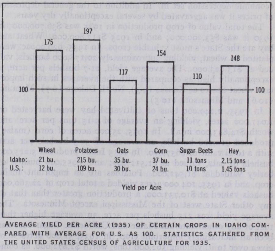
The total value of crop production in 1935 was $36,700,000; in 193o it was $53,200,000; and in 1925 $117,800,000. Wheat and hay are the State's most valuable crops. In 1935, 929,000ac. were planted to wheat, yielding approximately 20,178,00o bushels, val ued at $13,923,000. The average yield, 21.7 bushels per acre, is exceptionally high as compared with the averages in such impor tant wheat States as Kansas (9.3), North Dakota (6.7), Montana (10.6) and Minnesota (10.5).
In 1935, 2, 249,00o tons of cultivated hay were harvested on I,o47,00o acres, yielding an average of 2.15 tons per acre, and worth $14,843,00o in all. In 1935, 25,00o acres of corn (maize) produced 912,00o bushels, an average of 36.5 bushels per acre with a total value of $657,000. In 1935 Idaho produced 5,215,000 bushels of oats, valued at $I,512,000; and bushels of barley valued at $I,S42,000. Potatoes are an important Idaho crop, and in 1935, Io4,000 acres yielded a total crop of 22,360,000 bushels valued at $Io,733,000, a production greater than that of any other State west of the Mississippi except Minnesota. The average yield was 215 bushels per acre, an average higher than that of any other state but Maine and California. Sugar-beet has been an increasingly important crop; in 1935, 51,00o acres were given over to it, yielding 562,00o tons, worth $2,87 2,000, as com pared with 38,00o acres in 1925, yielding 486,00o tons worth $3,027,000. These statistics do not include the benefit payments or government purchases of farm crops by the Agricultural Ad justment Administration. A total of $13,938,867 was reported paid to Idaho fanners by the Agricultural Adjustment Administration from May 1933, when the bureau began functioning to June 1936 when it ceased.
Idaho has consistently shipped more apples than any other State in the Union except the State of Washington. The principal varieties are the Jonathan and the Rome Beauty. The principal growing valleys are the Boise and the Payette and those around Lewiston. The United States agricultural census of 1935 showed production at 5,934,00o bushels of apples valued at 16o,000 bushels of peaches worth $136,000; S7,000 bushels of pears worth $S7,000; and 554 tons of grapes worth $22,160.
As there are no large consuming centres in Idaho, growers must seek distant markets. These have been opening up rapidly on the Pacific coast, especially in California. This has also stimulated dairying. Milch-cows and heifers increased from 178,00o head in 193o to 190,00o head in 1936, while the total for all cattle rose from 62 2,00o to 768,000. Creamery butter produc tion rose from 26,021,000lb. in 1929 to 28,910,00o in 1934. Milk production rose from 104,667,00o gallons to 106,989,00o gal lons in the same years. In 1936 horses numbered 190,00o and swine 215,000.
The sheep-raising industry in the State suffered as a result of the economic depression. The total number of sheep dropped from in 1930, to 2,104,00o in 1936. The price of wool has continued to be low since 193o and in 1935 Idaho's output was 18,567,00o pounds as compared with 18,156,00o for 1930. The average weight per fleece is nine pounds. Near Du Bois there is a United States sheep experiment station of 44,81 o acres devoted to a study of the problems of range sheep men in the West.
Mining.—The total value of Idaho's mineral production from the discovery of gold in 186o to 1927 is estimated at $1,030,000, 000. The leading minerals in the order of their importance are lead, silver, gold, zinc and copper. The annual production of these minerals in the decade before the World War averaged $24,500,00o in value. During the war the output of lead, silver, zinc and copper, because of the high prices these metals com manded, increased over i00%, but the production of gold de creased 6o%. The total mineral production of 1917 was valued at $54,845,153. After the war the decline in demand and prices, combined with high freight rates and high wages, caused severe de pression. Between 1921 and 1929, however, prices of metals slowly increased, so that old mines were reopened and new developments and explorations carried out. Beginning in 1930, the economic depression caused the greatest slump in mining in Idaho's history. The value of mineral production fell from $3 2,143,00o in 1929 to in 1932. However, conditions improved steadily begin ning in The total value of the five leading metals of the State in was $15,239,000, an increase of $3,778,000 over that of 1933. The increase was for the most part in the amount of the gold and silver produced and in the higher prices at which these metals sold, the gold output being worth $1,650,977, and the silver The devaluation of the dollar in which increased the domestic price of gold to $35 per ounce, and the Silver Purchase Act of increasing the treasury purchases of silver, are responsible for the boom in gold and silver production. The copper output of the State decreased slightly, but higher prices gave it a value of $122,400. There was a substantial increase in the production of zinc, the 1934 output being $2,150,000, but a slight decrease in the production of lead, the valuation, $5,2S4,000, being $249,00o below that of 1933. However, general European rearma ment programs (1937) promise to increase the production of these metals. Of the State's mineral production over 90% is from the rich lode belt in Shoshone county. The year was also a better one for labour. Gold miners averaged over $5.00 per day.
The lead, silver and zinc ores are always found associated with each other, and the mining of one can hardly be carried on sep arately from the other. Much of Idaho's success in mining has been due to milling experiments and inventions which make it possible to treat these complex ores at very little increase in mill ing costs, giving at the same time high-grade concentrates and in creased percentage of recovery.
Only Missouri produced more lead than Idaho until 1925, when Utah in certain years surpassed Idaho. Idaho was the great pro ducer of silver in the United States. Only a few regions there have been thoroughly prospected. Lead-zinc-silver discoveries in the granite areas of Valley and Custer counties in 1925 attracted nation-wide attention. Other known deposits, in remote regions, await transportation facilities before they can be developed. The mining industry has suffered greatly from speculative promotion, which is now curtailed by "blue sky" laws and the S.E.C. act of requiring the filing of all publicity literature, so that some check can be made upon the truth of promoters' claims.
Idaho ranks as the fifth State in the Union in the richness of its water-power resources, so that an ample and cheap supply for future manufacturing is assured. In resources developed, Idaho in 1936 was seventeenth among the States, 56 plants developing 355,222 h.p. The generation of all transmission lines in that year was 16,079,407 h.p. Water-power resources still undeveloped were estimated by the U.S. geological survey at from 2,262,000 to 5,067,00o horse-power.
Lewis and Clark were none too early, for in 1809 David Thompson and Finan McDonald, traders of the North-West Company, a British organization, entered Idaho from the north and on the shores of Lake Pend Oreille built a trading post, the first building in the State. In the spring of 1809-10, 46 packs of fur of 90 lb. each were taken out—Idaho's first commercial contribution to the outside world. In 1810 Andrew Henry, of the Missouri Fur company, built the second building in Idaho, on Henry's Fork of the Snake river, the first establishment of a citizen of the U.S. west of the continental divide. Another expedition from the U.S. consisting of 56 men under the com mand of Wilson Price Hunt, was sent overland to the mouth of the Columbia river by John Jacob Astor, and visited Fort Henry in 1811. Their adventures and disasters in attempting to cross southern Idaho are accurately and vividly told by Washington Irving in Astoria. They were the first party to make the trip along the route later followed, in the main, by the Oregon trail.
During the War of 1812 the Americans were forced to give up the region ; and with little competition, British traders con trolled the fortunes of Idaho for the next 35 years. In 1818 Donald McKenzie was put in charge of the Snake river brigade, and for four years he led large trapping parties into the region, searching for the best beaver territory. These expeditions were continued for many years by Peter Skene Ogden and John Work, later chiefs of the brigade. Their journals show the thor oughness of their knowledge of the region's topography. In Nathaniel Wyeth, a Boston man, built Fort Hall on the upper Snake river in an ambitious attempt to establish a trade in the region. To draw away his trade the Hudson's Bay Company built Fort Boise the same year. Both forts later became famous hostelries to emigrants on the Oregon trail.
Movements over this trail began in 1842, when Dr. Elijah White led the first party of ioo to Oregon. Extensive travel began the following year, the first train numbering nearly i,000 men, women and children. Except for those unfortunates who found graves by the wayside, none of these travellers remained in Idaho, nor did those thousands remain who later crossed south-eastern Idaho on the California trail. It was a back-wave of this emigration, lured by the discoveries of gold in 186o, that was to result in the permanent settling of the State.
Meanwhile, the Rev. Henry Spalding and his wife, sent out by the American Board for Foreign Missions, had established a school for the Indians on Lapwai creek, east of Lewiston (1836), and the first home of a white family where the first white child was born and reared. Seeds were planted in the hope of interesting the Indians in agriculture, and apple trees were set out and irrigating and power ditches were made and used, at the end of which was established and operated a small grist and sawmill. The first printing-press in the Oregon country was brought to Lapwai by pack-horse and set up to print a primer, a hymn-book and the Gospel of Matthew in the Nez Perce language. Father Desmet, the pioneer of Catholicism in the North-west, also established the Sacred Heart mission among the Coeur d'Alene Indians in 1842. In the spring of 1846 William Craig located a few miles up Lapwai creek from the Spalding mission a homestead of 64o ac., under the Oregon dona tion act, the earliest title in Idaho for which a patent was issued. although the title initiated by the Spalding Mission site ten years earlier was recognized and bought later by the Government be fore issuance of patent. A Mormon mission and colony had been attempted in the valley of the Lemhi river in 1855, but were recalled by President Young in 1858 because of the hos tility of the Bannock and Shoshone Indians. In 186o a band of Mormon home-seekers made the first permanent agricultural settlement, at Franklin, just north of the southern boundary. They thought themselves to be still in Utah, but the survey later showed they were in Idaho. Here they proceeded to irrigate their little ten-ac. tracts and opened the first school for whites.
The discovery of gold by Capt. E. D. Pierce in 1860 upon Orofino creek, a tributary of the Clearwater river, was more potent in the immediate fortunes of the territory. News of the rich strike started a stampede from Walla Walla in the spring of 1861. In May there were a thousand men in the new town of Pierce city, where, about Sept. i, the officials of the first county in Idaho began functioning, though as Shoshone county of Washington territory. Lewiston was founded at the con fluence of the Snake and Clearwater rivers, where the boats un loaded and the pack-trains started. Prospectors soon claimed other deposits, and Elk city and Florence became the lively centres of new districts to the south. More permanent deposits were dis covered at Warren in 1862. Pack-horse trails were the only ap proach to some of these famous camps high in the rugged mountains.
Gold was discovered in the Boise basin of southern Idaho in 1862. By 1864 there were 16,000 people in the basin. Idaho city was the metropolis. Discoveries were also made in Owyhee county, where Ruby city and Silver city became the main camps. Silver ledges and gold-bearing quartz were found, and eastern capital was attracted by unmistakable signs of permanency. Idaho was organized as a territory in 1863, including, in addi tion to its present limits, also Wyoming, Montana and the por tions of Nebraska, North and South Dakota west of the eastern line of Colorado continued north. William H. Wallace was op pointed the first governor, and in December the first legislature met in Lewiston. In the second legislature, southern Idaho men predominated, and the capital was moved to Boise, where it has since remained. Idaho's first newspaper, the Golden Age, was started in Lewiston, Aug. 2, 1862, and in 1863 the publishing of the first southern Idaho newspaper, the Boise News, began. In 1864 two stage lines were established from the Columbia river in the basin, and one from Salt Lake city. The telegraph did not reach Boise until 1875.
The influx of miners and ranchers on territory reserved for the Indians made the tribes restless. There were three outbreaks between 1870 and 1880. The Nez Perce chiefs refused to sign a treaty giving up fertile valleys where the whites had already settled; and when the Government tried to coerce them, they resisted. One expedition sent against them was disastrously defeated in Whitebird canyon. After a long period of skirmish ing Gen. Howard met the Indians in a two days' battle near Kamiah. A charge the second day dislodged the Indians from their riflepits, and they fled eastward over the Lo Lo trail. It was the beginning of Chief Joseph's masterly retreat of 1,300m., which ended when he was finally captured by Gen. Miles in the Bear Paw mountains of Montana. The Bannocks, in an ugly mood after the Nez Perce war, would not stay on their reserva tion, and hostilities ensued. Their resistance might have been formidable had not Buffalo Horn, their able leader, been killed early in the war. This broke their spirit, and Gen. Howard easily defeated the disorganized remnants of their forces.
The first agricultural and live stock developments began in valleys near the mining districts. Such were the Boise, Payette and Weiser valleys and the valleys in the vicinity of Lewiston. Some settlers raised garden vegetables and oats and wheat, while others merely kept horse ranches, and cut the hay along the river bottoms for feed. Ranches of the latter sort became numerous along the Oregon and Montana trails. Cattle and sheep also reached Idaho over the Oregon trail, the owners of the herds settling in the fertile valleys along the route. Spanish cattle came from Utah and California. Drought in California in the years 1863, 1864 and 1871 sent large herds northward. By the ranges were well stocked, and the next year the first drove was sent east. The stock industry naturally began in the southern counties because the country was not so heavily wooded, nor was it so far from the Union Pacific railway, which was de pended upon for transportation. The Oregon Short line, which was built across southern Idaho in 1882-84, greatly stimulated stock raising and general settlement. The building of the North ern Pacific across northern Idaho, 188o-82, did the same for that region. One of the wildest stampedes in the history of mining took place into this northern Coeur d'Alene country in 1884. The quartz then discovered was to make this one of the richest silver-lead regions in the world.
Farming in southern Idaho depended upon irrigation. Private enterprises in favourable localities were first resorted to, but the land that could be so irrigated was limited. Corporations were then formed to build larger canal systems. But they be care so exorbitant in their demands and partial in their grants of water that the farmers hated them. Laws were passed whereby farmers themselves could control irrigation ditches. In 1894 the Carey act gave each of the States i,000,000ac. if the State would undertake to irrigate the land. After 1902 development under this act was rapid, and Idaho has a greater number of Carey projects than any other State. In 1902 Congress passed the Reclamation act, providing for the financing of large devel opments by the Federal Government. The growth of dry-farming in the second decade of the present century raised the income from agriculture far above that from mining, which had formerly been the most valuable industry.
The State's recent political leaning has been toward Populists, Democrats, or Progressives in preference to straight Republicans. During the twenties it supported Harding, Coolidge, and Hoover successively. But in 1932 and 1936 it gave its overwhelming sup port to Franklin D. Roosevelt and the New Deal, except for the Senatorial seat given to William E. Borah for the sixth time.