
CANADA. The Dominion of Canada comprises the northern half of the continent of North America and its adjacent islands, excepting Alaska, which belongs to the United States, and New foundland, which is a separate dominion of the British empire. The north-eastern coast of Labrador belongs to Newfoundland. Its boundary on the south is the parallel of latitude 49°, between the Pacific Ocean and Lake-of-the-Woods, then a chain of small lakes and rivers eastward to the mouth of Pigeon river on the north-west side of Lake Superior, and the Great Lakes with their connecting rivers to Cornwall, on the St. Lawrence. From this eastward to the state of Maine the boundary is an artificial line nearly corresponding to latitude ; then an irregular line partly determined by watersheds and rivers divides Canada from Maine, coming out on the Bay of Fundy. The western boundary is the Pacific on the south, an irregular line a few miles inland from the coast along the "pan handle" of Alaska to Mount St. Elias, and the meridian of to the Arctic Ocean. For much additional information concerning Canada, see BRITISH EMPIRE.
More than half Canada's surface slopes gently inwards towards the shallow Hudson Bay, with higher margins to the south-east and south-west. In the main it is a broad trough, wider towards the north than towards the south and unsymmetrical, Hudson Bay occupying much of its north-eastern part, while to the west broad plains rise gradually to the foot-hills of the Rocky Mountains.
In the Cordilleran region on the other hand the lakes are long, narrow and deep, in reality sections of mountain valleys occupied by fresh water, just as the fjords of the adjoining coast are valleys occupied by the sea. The smaller lakes are often rimmed with marshes and are slowly filling up with vegetable matter, ultimately becoming peat bogs, the muskegs of the Indian. Most of Canada is so well watered that the lakes have outlets and are kept fresh, but there are a few small lakes in southern Saskatchewan, e.g., the Quill and Old Wives lakes, in regions arid enough to require no outlets. In such cases the waters are alkaline, and contain various salts in solution which are deposited as a white rim round the basin towards the end of the summer when the amount of water has been greatly reduced by evaporation. It is interesting to find maritime plants, such as the samphire, growing on their shores a thousand miles from the sea and more than a thousand feet above it. In many cases the lakes of Canada simply spill over at the lowest point from one basin into the next below, so that canoe navigation may be carried on for hundreds of miles, with here and there a waterfall or rapid requiring a portage.
The river systems are in many cases complex and tortuous, and very often the successive connecting links between the lakes re ceive different names, well illustrated by the St. Lawrence, which may be said to begin as Nipigon river and to take the names St.. Mary's, St. Clair, Detroit and Niagara, before finally flowing from Lake Ontario to the sea under its proper name. As these lakes are great reservoirs and settling basins, the rivers which empty them are unusually steady in level and contain clear water. The St. Lawrence varies only a few feet in the year and always has pel lucid bluish-green water, while the Mississippi, whose tributaries begin only a short distance south of the Great Lakes, varies 40 ft. or more between high- and low-water and is loaded with mud. The St. Lawrence has provided the main artery of exploration and with its canals past rapids and between lakes serves as a great highway of trade between the interior of the continent and the seaports of Montreal and Quebec. It is probable that politically Canada would have followed the course of the States to the south but for the planting of a French colony with widely extended trading posts along the easily ascended channel of the St. Law rence and the Great Lakes, so that this river was the ultimate bond of union between Canada and the empire.
North of the divide between the St. Lawrence system and Hud son Bay there are many large rivers converging on that inland sea, such as Whale river, Big river, East Main, Rupert and Nottaway rivers coming in from northern Quebec ; Moose and Albany rivers with important tributaries from northern Ontario ; and Severn, Nelson and Churchill rivers from the south-west. They are rapid and shallow, but the largest of them, Nelson river, drains the great Manitoban lakes, Winnipeg, Winnipegosis and Manitoba, which are frequented by steamers, and receive the waters of Lake-of the-Woods, Lake Seul and many others emptying into Winnipeg river from Ontario ; of Red river coming in from the United States to the south; and of the southern parts of the Rocky Mountains and the western prairie provinces drained by the great Saskatchewan river.
The northern part of Alberta and Saskatchewan and much of northern British Columbia are drained through the Athabasca and Peace rivers, first north-eastwards towards Athabasca Lake, then north through Slave river to Great Slave Lake, and finally north west through Mackenzie river to the Arctic Ocean. If measured to the head of Peace river the Mackenzie has a length of more than 2,000 m., and it provides more than i,000 m. of navigation for stern-wheel steamers, serving the northern fur-trading posts.
Second among the great north-western rivers is the Yukon, which begins its course about 18 m. from tide-water on an arm of the Pacific, 2,800 ft. above the sea and just within the Canadian border. It flows first to the north, then to the north-west, passing out of the Yukon territory into Alaska, and ending in Bering Sea, 2,000 m. from its head-waters. The rest of the rivers flowing into the Pacific pass through British Columbia and are much shorter. The Columbia is the largest, but after flowing north-west and then south for about 400 m., it passes into the United States. The Fraser, next in size but farther north, follows a similar course, entering the sea at Vancouver; while the Skeena and Stikine in northern British Columbia are much shorter and smaller, owing to the encroachments of Peace and Liard rivers, tributaries of the Nelson, on the Cordilleran territory. In most cases these rivers reach the coast through deep valleys or profound canyons, and the transcontinental railways find their way beside them, the Canadian Pacific following at first tributaries of the Columbia near its great bend, and afterwards Thompson river and the Fraser; while the Canadian National makes use of the valley of the Skeena and its tributaries.
The divide between the rivers flowing west and those flowing east and north is very sharp in the southern Rocky Mountains, but there are two lakes, the Committee's Punch Bowl and the Fortress Lake, right astride of it, sending their waters both east and west; and the melting snows of the Columbia ice-field drain in three directions into tributaries of the Columbia, the Saskatch ewan and the Athabasca, so that they are distributed between the Pacific, the Atlantic (Hudson Bay) and the Arctic Oceans. The divide between the St. Lawrence and Hudson Bay in eastern Canada is flat and boggy instead of being a lofty range of moun tains.
As most of the Canadian rivers have waterfalls on their courses, they are of much importance as sources of power. The St. Law rence system, for instance, generates many thousand horse-power at Sault Ste. Marie, Niagara and the Lachine rapids. All the larger cities of Canada make use of hydro-electric power, and many enterprises of the kind have been carried out in eastern Canada, especially in Quebec.
From the summit of any of the higher hills one sees that the region is really a somewhat dissected plain, for all the hills rise to about the same level with a uniform skyline at the horizon. The Archaean protaxis is sometimes spoken of as a plateau, but prob ably half of it falls below i ,000 ft. The lowland part extends from to soo m. round the shore of Hudson Bay, and reaches south west to the edge of the Palaeozoic rocks on Lake Winnipeg. Out wards from the bay the level rises slowly to an average of about 1,500 ft., but seldom reaches 2,000 ft. except on the eastern and southern coasts of Labrador. In most parts the Laurentian hills are bare roches moutonnees scoured by the glaciers of the Ice age, but a broad band of clay land extends across northern Quebec and Ontario just north of the divide. The edges of the protaxis are in general its highest parts, and the rivers flowing outwards often have a descent of several hundred feet in a few miles towards the Great Lakes, the St. Lawrence or the Atlantic, and in some cases they have cut back deep gorges or canyons into the tableland. The waterfalls are utilized at many points to work up into wood pulp the forests of spruce which cover much of Labrador, Quebec and Ontario.
As one advances northward the timber grows smaller and in cludes fewer species of trees, and finally the timber line is reached near Churchill on the west coast of Hudson Bay and somewhat farther south on the Labrador side. Beyond this are the "barren grounds" on which herds of caribou (reindeer) and musk ox pas ture, migrating from north to south according to the season. There are no permanent ice sheets known on the mainland of north eastern Canada, but some of the larger islands to the north of Hudson Bay and Straits are partially covered with glaciers on their higher points. Unless there are mineral resources, the bar ren grounds can never support a white population and have little to tempt even the Indian or Eskimo, who visit it in summer to hunt the deer in their migrations.
The province of New Brunswick exhibits approximately par allel but subordinate ridges, with wide intervening areas of nearly flat Silurian and Carboniferous rocks. The peninsula of Nova Scotia, connected by a narrow neck with New Brunswick, is formed by still another system of parallel ridges, deeply fretted on all sides by bays and harbours. Valuable coal-fields occur in Cape Breton and other parts of the province. Gypsum is quarried on a large scale in both provinces. Asbestos is the principal min eral product of that part of Quebec included in the region now under consideration. Extensive tracts of good arable land exist in many parts of the Acadian region. Its surface was originally al most entirely wooded, and the products of the forest continue to hold a prominent place. Prince Edward Island, the smallest prov ince of Canada, is low and undulating, based on Permo-Carbon iferous and Triassic rocks affording a red and very fertile soil, much of which is under cultivation.
The highest mountains of the Cordillera in Canada are near the southern end of the boundary separating Alaska from the Yukon Territory, the meridian of i45° and they include Mount Logan (19,85o ft.) and Mount St. Elias (i 8,000 ft.), while the highest peak in North America, Mount McKinley (20,000 ft.) is not far to the north-west in Alaska. Near the height of land between British Columbia and Alberta there are many peaks which rise from i o,000 to i 2,000 ft. above sea-level, the highest being Mount Robson (12,972 ft.). The next range to the east, the Selkirks, has summits that reach r i,000 ft. or over, while the Coast Ranges sometimes reach 13,00o ft. The snow line in the south is from to 9,00o ft. above sea-level, being lower on the Pacific side where the heaviest snowfall comes in winter than on the drier north-eastern side. It gradually sinks as one advances north-west, reaching only 3,00o ft. on the Alaskan coast. The Rockies and Selkirks support hundreds of glaciers, mostly not very large, but some having i oo sq.m. of snowfield.
All the glaciers are now in retreat, with old tree-covered mo raines, hundreds or thousands of feet lower down the valley. The timber line is at about 7,500 ft. in southern British Columbia and 4,000 ft. in the interior of the Yukon Territory. On the westward slopes, especially of the Selkirks and Coast Ranges, vegetation is almost tropical in its density and luxuriance, the giant cedar and the Douglas fir sometimes having diameters of i o ft. or more and rising to the height of 25o ft. On the eastern flanks of the ranges the forest is much thinner, and on the interior plateau and in many of the valleys largely gives way to open grass land. The Coast Range was formed by a great upwelling of granite and diorite as batholiths along the margin of the continent in the Jurassic. The Rocky Mountains were raised after the close of the Cretaceous by tremendous thrusts from the Pacific side, crumpling and fold ing the ancient sedimentary rocks, and faulting them along over turned folds. The outer ranges in Alberta have usually the form of tilted blocks with a steep cliff towards the north-east and a gentler slope, corresponding to the dip of the beds, towards the south-west. Near the centre of the range there are broader fold ings, carved into castle and cathedral shapes. The most easterly range was pushed 7 m. out upon the prairies.
In the Rocky Mountains proper no ore deposits are known, but in the Cretaceous synclines which they enclose, valuable coal basins exist. The coking coals of the Fernie region supply the fuel of the great metal mining districts of the Kootenays in British Co lumbia, and of Montana and other states to the south. In the Coast and Gold Ranges there are important mines of gold, silver, copper and lead and in early days the placer gold mines of the Columbia, Fraser and Cariboo attracted miners from everywhere, but these have declined, and lode mines supply most of the gold as well as the other metals. The Atlin and White Horse regions in northern British Columbia and southern Yukon have attracted much attention, and the Klondike placers still farther north have furnished many millions of dollars' worth of gold, but are now al most worked out.
In Canada the isotherms by no means follow parallels of lat itude, especially in summer when in the western half of the coun try they run nearly north-west and south-east, so that the average temperature of 55° is found about on the Arctic circle in the Mac kenzie river valley, in latitude 5o° near the Lake-of-the-Woods, in latitude 55° at the northern end of James Bay, and in latitude 49° on Anticosti in the Gulf of St. Lawrence. It is impossible to de scribe even the climate of a single province, like Ontario or British Columbia, as a unit, as it varies so greatly in different parts. De tails should therefore be sought in articles on the separate prov inces. South of the Gulf of St. Lawrence the maritime provinces average 40° for the year and over 6o° for the summer months. The amount of rain is naturally high so near the sea, 4o to 56 in., but the snowfall is not usually excessive. In Quebec and northern On tario the rainfall is diminished, ranging from 20 to 4o in., while the snows of winter are deep and generally cover the ground from the beginning of December to the end of March. The winters are bril liant but cold, and the summers average from 6o° to 65°, with clear skies and a bracing atmosphere which makes these regions favourite summer resorts for the people of the cities to the south. The winter storms often sweep a little to the north of southern On tario, so that what falls as snow in the north is rain in the south, giving a much more variable winter, often with little snow. The summers are warm, with an average temperature of 65° and an occasional rise to 90°.
As one goes westward the precipitation diminishes, most of it, however, coming opportunely from May to August, the months when the growing grain most requires moisture. There is a much lighter snowfall than in northern Ontario and Quebec, with some what lower winter temperatures. The precipitation in southern Saskatchewan and Alberta is much more variable than farther east and north, so that in some seasons crops have been a failure through drought, but large areas are now being brought under irri gation to avoid such losses. The prairie provinces have a distinctly continental climate with comparatively short, warm summers and long, cold winters, but with much sunshine in both seasons. In southern Alberta the winter cold is often interrupted by chinooks, westerly winds which have lost their moisture by crossing the mountains and become warmed by plunging down to the plains, where they blow strongly, licking up the snow and raising the tem perature, sometimes in a few hours from to 40°. In this region cattle and horses can generally winter on the grass of the ranges without being fed. With sunshine for twenty hours out of twenty four in June, growth is almost the same in the north as for hun dreds of miles to the south, so that wheat and vegetables ripen in the Peace river valley in latitude 56°.
The climate of the Cordilleran region presents even more va riety than that of the other provinces because of the ranges of mountains which run parallel to the Pacific. Along the coast itself the climate is insular, with little frost in winter and mild heat in summer, and with a very heavy rainfall amounting to r oo in. on the south-west side of Vancouver Island and near Prince Rupert. Beyond the Coast Range the precipitation and general climate are comparatively mild and with moderate snowfall towards the south, but with keen winters farther north. The interior plateau may be described as arid, so that irrigation is required if crops are to be raised.
The Selkirk Mountains have a heavy rainfall and a tremendous snowfall on their western flanks, but very much less precipitation on their eastern side. The Rocky Mountains have the same rela tionships but the whole precipitation is much less than in the Sel kirks. The temperature depends largely, of course, on altitude, so that one may quickly pass from perpetual snow above 8,000 f t. in the mountains to the mild, moist climate of Vancouver or Victoria. North-west and north-east of Hudson Bay the climate becomes too severe for the growth of trees, and there may be perpetual ice beneath the coating of moss which serves as a non-conducting covering for the "tundras." Leaving out the maritime provinces, southern Ontario, southern Alberta and the Pacific coast region on the one hand, and the Arctic north on the other, Canada has snowy and severe winters, a very short spring with a sudden rise of temperature, short, warm summers and a delightful autumn with its "Indian summer." There is much sunshine, and the atmosphere is bracing and exhilarating. (A. P. Co.) Flora.—The general flora of the Maritime Provinces, Quebec and Eastern Ontario is much the same, except that in Nova Scotia a number of species are found common also to Newfoundland that are not apparent inland. In New Brunswick the western flora begins to appear as well as immigrants from the south, while in the next eastern province, Quebec, the flora varies considerably. In the lower St. Lawrence country and about the Gulf many Arc tic and sub-Arctic species are found. From the city of Quebec westwards there is a constantly increasing ratio of southern forms, and when Montreal is reached the representative Ontario flora be gins. In Ontario the flora of the northern part is much the same as that of the Gulf of St. Lawrence, but from Montreal along the Ottawa and St. Lawrence valleys the flora takes a more southern aspect, and trees, shrubs and herbaceous plants not found in the eastern parts of the Dominion become common.
In the forest regions north of the lakes the vegetation on the shores of Lake Erie requires a high winter temperature, while the east and north shores of Lake Superior have a boreal vegetation that shows the summer temperature of this enormous water stretch to be quite low. Beyond the forest country of Ontario come the prairies of Manitoba and the North-West Territories. In the ravines the eastern flora continues for some distance, and then disappearing gives place to that of the prairie, which is found everywhere between the Red river and the Rocky Mountains ex cept in wooded and damp localities. Northwards, the flora of the forest and that of the prairies intermingle. On the prairies and the foot-hills of the Rocky Mountains a great variety of grasses is found. Besides the grasses there are many leguminous plants valuable for pasture.
About the saline lakes and marshes of the prairie country are found Ruppia maritima, Heliotropium curassavicum, natives of the Atlantic coast, and numerous species of Chenopodium, Atri plex and allied genera. The flora of the forest belt of the North West Territories differs little from that of northern Ontario. At the beginning of the elevation of the Rocky Mountains there is a lux urious growth of herbaceous plants, including a number of rare umbellifers. At the higher levels the vegetation becomes more Arctic. Northwards the valleys of the Peace and other rivers differ little from those of Quebec and the northern prairies. On the western slope of the mountains, that is, the Selkirk and Coast ranges as distinguished from the eastern or Rocky mountain range, the flora differs, the climate being damp instead of dry. In some of the valleys having an outlet to the south the flora is partly peculiar to the American desert, and such species as Purshia tridentata and Artemisia tridentata, and endemic species of Gilia, Aster and Erigonum are found. Above Yale, in the drier part of the Fraser valley, the absence of rain results in the same character of flora, while in the rainy districts of the lower Fraser the vegetation is so luxuriant that it resembles that of the tropics. So in various parts of the mountainous country of British Colum bia, the flora varies according to climatic conditions. Nearer the Pacific coast the woods and open spaces are filled with flowers and shrubs. Liliaceous flowers are abundant, including various species of Erythronium, Trillium, Allium, Brodeaea, Fritillaria, Lilium and Camassia. (X.) Fauna.—The larger animals of Canada are the musk-ox and the caribou of the barren lands, both having their habitat in the far north ; the caribou of the woods, found in all the provinces except Prince Edward Island; the moose, with an equally wide range in the wooded country; the Virginia deer, in one or other of its varietal forms, common to all the southern parts; the black-tailed or mule deer and allied forms, on the western edge of the plains and in British Columbia; the pronghorn antelope on the plains, and a small remnant of the once plentiful bison in northern Alberta and Mackenzie. The wapiti or American elk at one time abounded from Quebec to the Pacific, ranging as far north as the Peace river, but is now found only in small numbers from Manitoba westward.
In the mountains of the west are the grizzly bear and the black bear. The black bear is also common to most other parts of Canada ; the polar bear everywhere along the Arctic littoral. The large or timber wolf is found in the wooded districts of all the provinces, and on the plains there is also a smaller wolf called the coyote. In British Columbia the puma or cougar still fre quently occurs ; and generally distributed in wooded areas are the common fox and its variety, the silver fox, the lynx, beaver, otter, marten, fisher, mink, skunk and other fur-bearing animals. The wolverene is largely confined to the barren lands, which are also inhabited by the arctic fox. Mountain and plain and Arctic hares and rabbits are plentiful or scarce in localities, according to seasons or other circumstances. In the mountains of British Columbia are the bighorn or Rocky Mountain sheep and the Rocky Mountain goat, while sheep of two or three other species are also found from nearly pure white in the north to black in certain areas in the southern Canadian Rockies.
The birds of Canada are mostly migratory, and are those common to the northern and central states of the United States. The wildfowl are, particularly in the west, in great numbers; their breeding grounds extending from Manitoba and the western prairies up to Hudson Bay and the barren lands and Arctic coasts. The several kinds of geese—including the Canada goose, the Arctic goose or wavey, the laughing goose, the brant and others all breed in the northern regions, but are found in great numbers throughout the several provinces, passing north in the spring and south in the autumn. There are several species of grouse, in cluding the ruffed grouse, ptarmigan and sharp-tailed grouse of the plains. In certain parts of Ontario the wild turkey formerly occurred, and the so-called "quail" or "bob-white" still inhabits the southern part of the province.
The golden eagle, bald eagle, osprey, and a large variety of hawks are common in Canada, as are the snowy owl, the horned owl and other owls. The raven is found only in the less populated districts, but the crow is common everywhere. Song-birds are plentiful, especially in the wooded regions, and include the Ameri can robin, oriole, thrushes, the catbird and various sparrows; while the introduced English sparrow has multiplied excessively and become a nuisance in the towns. More recently introduced but spreading rapidly are the European starling in the east and the Japanese starling in British Columbia. The smallest of the birds, the ruby-throated hummingbird, is found everywhere, even up to timber line in the mountains. The seabirds include a variety of gulls, terns, guillemots, cormorants and ducks, and in the Gulf of St. Lawrence the gannet is very abundant. Nearly all the sea-birds of Great Britain are found in Canadian waters or are represented by closely allied species.
The Migratory Birds Convention Act of 1923 involved an agree ment between the United States and Canada for the protection of bird life.
The land and water area of Canada was given by official figures for 1927 as 3,684,723 square miles, being about 3% larger than that of the Continental United States with Alaska (3,564,658 square miles) and about 2% smaller than that of the continent of Europe (3,776,700 square miles).
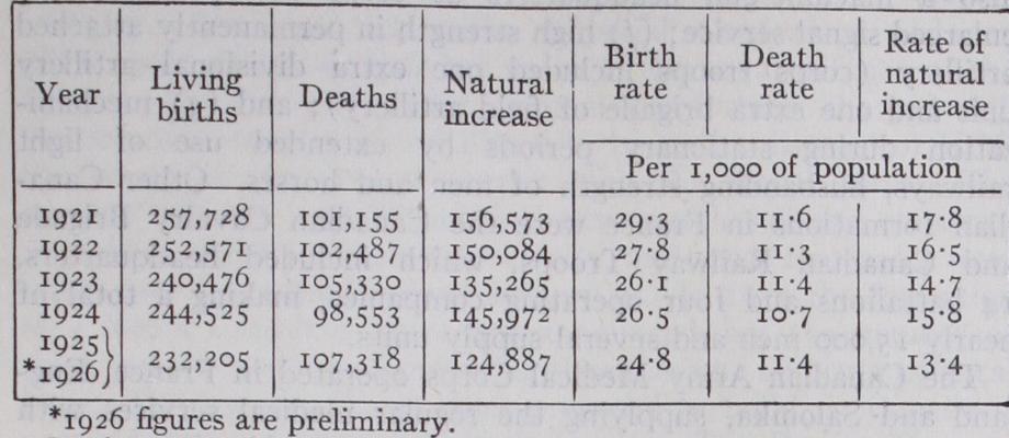
Population. The decennial census of Canada of June 1, 1921, showed a total population of 8,787,949- This figure was increased by the census of 1931 to a gain of 1,586,247 for the decade. The increase in percentage for that decade was 18.o5. Table 1 below shows the land and water areas of the various provinces and territories as of 1927, and the population as enumerated in the censuses of 1901, 1911. 1921, and 1931.

With regard to natural increase, only approximate figures were available prior to 1921. For the intercensal period 1901-1911 the surplus of births over deaths was estimated at 853,566 and for 1911-1921 at 1,150,659. The figures for the nine provinces for calendar years beginning with 1921 were as During 1926 the birth rates ranged from 32-1 per thousand in Que bec to 17.4 in British Columbia, while the rate of natural increase ranged from 17.6 per thousand in Quebec and Saskatchewan down to 7.8 per thousand in British Columbia. About one-third of the present natural increase is due to Quebec.
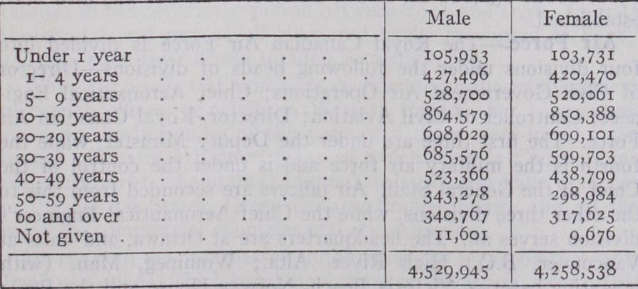
Largely as a result of immigration, the population is strongly masculine, the proportions being 515 males to 485 females. The same cause has affected the age distribution, so that an exception ally large proportion of the population is concentrated in the most productive years of life. The median age, which was 18.8o years in 1871, had increased to 23-94 years in 1921. The follow ing table shows the distribution by age and sex in 1921: Religious Denominations.—Of the total population of 1921, 97.5% were classified as belonging to some Christian denomina tion or sect, 1.9% as non-Christian (including Jews and adherents 'Quebec statistics are from provincial sources until 1926, when Quebec became a part of the Registration Area.
of Eastern religions) . The principal denominations were Roman Catholics 38.57%; Presbyterians, 16.o4%; Anglicans, 16.o2%; Methodists, 13.19%; Baptists, 4.80%; Lutherans, 3.26%; Greek Church, 1.93%; Jews, 1.42%; Mennonites, .67%; all others, 4.10%. Since the date of the 1921 census, there has been organ ized the United Church of Canada, which includes the groups formerly classed as Presbyterians, Methodists and Congregation alists, and now constitutes the largest single Protestant body. A large number of the Presbyterians did not enter this union, and this group continues as a separate denomination.
The British North America Act, which embodies the terms of the federal agreement of 1867, lays down, in sections 91-93, the subjects of legislation which are assigned respectively to the Do minion and the provinces. The former has exclusive legislative authority in all matters relating to the regulation of trade and commerce, military and naval defence, navigation and shipping, banking and currency, marriage and divorce, etc. ; the latter in all matters relating to education, municipal government, property and civil rights within the province, licenses, etc.
After the South African War an extensive scheme of reorgan ization was taken in hand. the command being exercised for two years (1902-1904) by Major-General Lord Dundonald, and sub sequently by a militia council (Militia Act 1904), similar in con stitution to the home Army Council.
After 1910 Canadian military organization changed very much. Its two most important features were the final war organization, and the peace organization which succeeded it. The principal mili tary effort of Canada from 1914 to 1918 consisted in the organi zation and maintenance of the Canadian Corps, consisting of the 1st. 2nd, 3rd. and 4th Canadian divisions and corps troops. This force, while technically an army corps of the British Army, differed from other army corps in that it was an integral tactical unit. moving and fighting as a whole.
The Canadian Army Medical Corps operated in France, Eng land and Salonika, supplying the regular medical services with the corps and other troops and also 14 general and seven sta tionary hospitals, four small forestry corps hospitals, 12 conva lescent hospitals and one mobile laboratory. The Canadian Forestry Corps operated in England and France with 24.000 all ranks. The Canadian Army Dental Corps had a strength of 9o3 all ranks. Special formations were the Accountant General's Branch, the Canadian Army Pay Corps and the Department of the General Auditor. Canadian troops in France and England were administered by the Minister of Overseas Military Forces of Canada with a headquarters in London.
(X.) Navy.—Not until of ter the Imperial Conference of 1909 did Canada decide to bear her share in the naval defence of the Empire. In 1910, a Navy Department was formed, charged with the organization of a Naval Force, to be at the disposal of H.M. the King for the general service with the Royal Navy. The cruisers "Niobe" and "Rainbow" were purchased and stationed at Halifax and Esquimalt respectively, and these two bases were taken over from the Imperial authorities. In 1911 the formation of a Royal Canadian Navy was announced, but the number of ships and the method of providing them became an acute political issue. The Laurier Government proposed to build, in Canada if possible, four cruisers and six destroyers. The Borden Govern ment plan was to lay down three battleships for the Royal Navy, which should be at the call of the Royal Canadian Navy, when that force came into existence. Neither plan materialized before the outbreak of the war in 1914. During the war the two old cruisers, assisted by a destroyer and two submarines were em ployed in patrolling, and, on both Atlantic and Pacific Coasts, large flotillas, manned chiefly by volunteers, came into being and did all patrol, minesweeping and convoy protection work in Canadian waters.
After the visit of Lord Jellicoe to Canada in 1919 the Canadian Government decided to maintain the Navy at pre-war level and the Imperial Government presented to Canada a light cruiser and two destroyers to replace the obsolete ships. The war time personnel was demobilized and re-organized and in 1922 the Navy Department was amalgamated with the Department of National Defence. In 1936 the authorized permanent personnel of the Royal Canadian Navy was 117 officers and 862 men, the latter serving as a rule under seven year engagements ; the establish ment of the Naval Reserve, recruited from among the seagoing population, was 7o officers and 43o men enrolled for five years; and the Naval Volunteer Reserve numbered Io officers and 93o men under a three year enrolment. Four destroyers and one mine sweeper were maintained in commission ; and there were training posts, dockyards, and shops at Halifax and Esquimalt.
(S. T. H. W.) Banking and Finance.—The Act of Confederation 1867 brought about the unified control of the banking system of the country, and by the Bank Act of 1871 a decennial revision of banking law was provided for. This system has worked smoothly, and changes have been in the way of natural development. The currency of the country is provided for by a restricted note issue of chartered banks secured by a system of mutual liability under which the assets of all the banks are liable for the notes of each one. In 1871 there were twenty-three chartered banks, with a paid-up capital of $40,000,000 and total assets of $136, 000,000. The maximum number of banks was forty-one in 1886. By 1931 this number had fallen to ten. Amalgamations and a few failures account for the reduction, but the direct loss to the public as a result of bank failures has been slight. There were no failures in the depression period between 1931 and 1936. In the capital and rest of all chartered banks amounted to $278, 250,000 while their assets totalled While the number of banks has declined to io the establishment of branch offices, especially in Western Canada, has been exten sive. At the beginning of the year 1936 there were in all 3,580 branch offices in existence, 3,431 of which were in Canada (one for every 3,19I inhabitants) . Canadian banks also have branches in the United States, Great Britain, France, Spain, and all the principal commercial countries of Latin America.
In 1934 an act was passed authorizing the incorporation of a Bank of Canada, which began operations on March II, 1935. This new agency, analogous in many of its functions to the Regional Banks of the U. S. Federal Reserve system, is required to main tain a gold reserve equal at least to 25% of its total note and deposit liabilities in Canada. Chartered banks, hitherto unre stricted as to their reserves against deposits, are now obliged to keep a reserve of at least 5% of their deposit liabilities within the Dominion in the form of deposits with and notes of the Bank.
The net debt of the Dominion in 1871 was about $78,000,000; in 1911 it was $340,042,052 and in 1924, The figure was reduced to $2,177,763,959 by but mounted again during the period of depression to $2,846,110,758 in 1935. In terest on the public debt in 1911 was in 1935 it was $138,533,202. War pensions, the growth of population, increas ing government activities, railway deficits and rising prices, all added to public expenditure, quite apart from the vast sums raised during the war (1914-18) for the maintenance of the army. The expenditure in 1911 on account of the consolidated fund was about $88,000,000. In 1935 it was $354,368,220. To this latter sum must be added the capital expenditures, railway deficits, and relief costs which brought the total expenditures to $478,004,747. The national wealth of Canada in 1933 was estimated at $25,768, 236,000 with the provincial distribution as follows : Ontario, $8,795,801,000; Quebec, $6,738,181,000; Saskatchewan, $2,527, 147,000; Alberta, $2,035,576,000; British Columbia, $2,430, 890,000; Manitoba, $I,562,42I,000; Nova Scotia, $790,290,000; New Brunswick, $130,297,000; Prince Edward Island, $138, 699,000; Yukon, $18,934,000. The wealth per capita averaged $2,413, being highest in Yukon, British Columbia, and Alberta. The national income in 1928 was estimated at $6,342,000,000; in 1933 it was estimated at $3,340,000,000. The amount of income assessed for income taxes in the former year was $1,040. 232,948; in the latter it was $944,091,564; and by 1935 it had fallen to The financial problem of the country was made more difficult by the burden of the vast railway system which had to be taken over by the Government soon after the War.
Customs duties were the largest source of revenue in 1935, fur nishing $76,561.975 of the $358,474,760 receipts of the con solidated fund. Excise duties were $43,189,655; income taxes amounted to $66,8o8,o66; sales taxes totalled $72,447,311; and taxes on cheques, transportation, etc. were $39,744,759• The combined yield of the last two items had trebled since 1931.
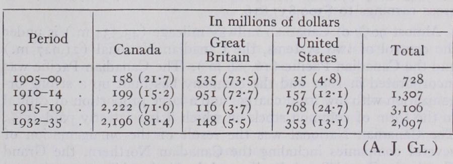
Canada was still a considerable borrower abroad in 1935, and it is important to note that after 1914 the greater part of these borrowings were from the United States, instead of Great Britain which had supplied nearly all the foreign capital borrowed by Canada before 1914.
The following table shows the nature of the change in respect to the sale of Canadian securities:— Communications and Transport.—Rapid increase in trans port facilities has been accompanied by improved communications. In 1934 telegraph wire mileage totalled 366,706 of which the Canadian National Telegraph owned 164,831 and the Canadian Pacific 177,800. Canada has six transoceanic cables, five on the Atlantic and one on the Pacific. The telegraph has been rapidly extended with wireless and radio stations. In 1935 there was a total of 815,124 stations. In 1934, 1,193,7 29 telephones were in use, or II.o per Ioo of population with 5,133,521 m. of wire. The number of post offices in operation declined from 12,409 in 1930 to 12,035 in 1934 but increased again to 12,069 in Postal revenues for 1935 were $36,185,222. In 1934 there were 4,343 rural mail routes with 238,764 boxes.
Canada is primarily a new country with a small population ex porting such bulky raw materials as wheat, lumber, pulp and paper, and minerals to densely populated industrial countries. Cheap water transportation is fundamental. Canadian ports are seriously affected by climatic considerations. Montreal is closed in the winter season and Halifax and St. John are too far distant from the interior to compete with United States Atlantic ports. Vancouver has benefited as an export centre for wheat by the opening of the Panama Canal. The export of wheat from the Prairie provinces intensifies the transport problem since it pro duces a peak load for Great Lakes shipping. The handling of great quantities of wheat during the rush season involves the use of specially constructed boats, "lakers," and of elaborate loading and unloading facilities at Port Arthur and Fort William, Port Col borne, Buffalo and the Georgian Bay ports. The Canadian Canal at Sault Ste. Marie has a depth of 19 feet and the American Canal 25 ft. The Welland Canal has been deepened to a minimum of 25 ft. so that lake boats of 22 ft. draught can proceed to the foot of Lake Ontario; and it is hoped that the St. Lawrence will be deepened to 3o ft. to permit ocean-going vessels to reach the lakes. Since confederation in 1867 Canada has expended $318, 332,293 chiefly on canals facilitating Great Lakes traffic. Toll charges on canals were abandoned in 1903.
Railway facilities have also been improved in relation to the ex port of wheat from the prairie provinces. Especially since 1900 railways have been rapidly extended for the development of traffic in western Canada, and the marked increase in the export of wheat has led to the construction of new lines from Winnipeg to Fort William and Port Arthur and from Georgian Bay ports to Mon treal as well as to the construction of a line from Winnipeg to Cochrane and Quebec. An additional outlet for trade of the Prairie provinces resulted from the completion in 1931 of a rail way to Churchill on Hudson bay. The development of the mineral industry and of pulp and paper mills in the Precambrian territory of Canada has been followed by the construction of numerous lines in northern Ontario and in northern Quebec, including the Temis kaming and Northern Ontario Railway and the lines to the Saguenay country, and in northern Manitoba. As in the case of canals, railway construction has involved heavy expenditures on the part of the federal and of the provincial governments. Land grants up to 1935 of the federal government total 31,881,642 ac., and of provincial governments ac., cash subsidies of the federal government $177,989,88o, of provincial governments and of municipalities $13,268,691, railway bonds guaranteed by the federal government and by pro vincial governments $93,261,489. Capital expenditures on govern ment railways to March 31, 1935 totalled $440,796,896; and provision is regularly made for deficits on these lines.
In 1934 the total capitalization of all Canadian railways was $4,606,323,231; operating expenses amounted to $251,991,667 and gross earnings to $300,837,816.
Almost 90% of Canadian railway mileage (43,334 m.) is under the control of two systems, the Canadian National (21,927 m.) and the Canadian Pacific (16,986 m.) . The Canadian Pacific was incorporated in 1881 and the company has built up a strong or ganization with low fixed charges and a large proportion of capital in the form of common stock on which it has latterly paid io%. The Canadian National was the result of the amalgamation of several companies including the Canadian Northern, the Grand Trunk, the Grand Trunk Pacific and the National Transcontinental which found themselves in difficulties through dependence on gov ernment guaranteed bonds and the high costs of operation during the war. The post-war period has been characterized by a joining up of the various units and a rounding out of the organization as a system. Both lines have connections with American roads and in 1934 the single-track mileage of Canadian railways within the borders of the United States was 339.
The financial position of these two important systems is closely dependent on railway rates. Rates are under the jurisdiction of the board of railway commissioners formed in 1903. It also regulates telephone, telegraph and express rates, and deals with problems of location, construction, and operation of the railways. The procedure of this Board is informal; 94.7% of the applications to it in 1934 were disposed of without formal hearings. To cope with some of the problems. which grew out of the depression, a special tribunal, with higher authority though narrower jurisdic tion than that of the Board, was created under the terms of the Canadian National-Canadian Pacific Act of 1933 to settle disputes between the two railway systems.
The transcontinental main lines with termini at the Canadian ports are supplied with traffic by numerous branch lines or feeders. In new territory further extension has been made with river steamboats, as on the Mackenzie and the Yukon and with the organization of air transport systems as in newly opened mining districts. Aircraft are used in new districts for passenger and mail service and in government work of surveying, mapping and preven tion of forest fires. In 1935, there were 38o licensed aircraft carrying a total personnel of 330,683 ; lb. of freight or express and 1,126,084 lb. of mail. The two railway companies have their own organization for handling express traffic.
Transport facilities have been improved with the introduction of the automobile and the construction of roads. In 1935 Canada had 409,269 miles of road, of which 315,627 miles were earth, miles gravel, 1,655 waterbound macadam, 3,214 bituminous macadam, 1,821 bituminous concrete, 1,906 cement concrete. Capital expenditures of the Dominion on roads in 1934 was while those of the provincial governments amounted to $29,952,814 and those of the municipalities to Motor vehicles had increased from 2,130 in 1907 to 1,129,532 in Each province has its own system of regulations, and in $50,622,683 were collected in taxes on motor vehicles. For short haul traffic in densely populated sections of Canada the motor vehicle has become a competitor of the railroads, but it has also been important in providing supplementary traffic for long distance railroad hauls.
Electric railways have decreased in mileage since 1925 as a result of the development of transportation by motor cars. In electric railway mileage totalled 1,293 m. and car mileage 120,035,625; passengers, 595,143,903; freight, 1,939,833 tons.
Improvement of inland transportation facilities has been re sponsible for a rapid growth of ocean shipping. In 1935 the total tonnage (of sea-going vessels) entered and cleared at Cana dian ports was 57,059,848. Of the total registered tonnage of vessels entered, 11,883,371 were British, 5,667,708 Canadian, and 10,961,178 foreign. Several steamship lines run between Canada and Great Britain and Europe on the Atlantic, and Canada and Asia and Australia on the Pacific. The Canadian Pacific operates an important subsidiary ocean steamship company and the Ca nadian National has a valuable ally in the Canadian Government Merchant Marine, which came into existence during the later years of the war. In 1925 this company had 49 vessels of a deadweight tonnage of 324,986 which made 235 voyages. On Dec. 31, 1934, however, its fleet had diminished to 1 o vessels with a deadweight of only 88,579 tons. (H. A. I.) Agriculture.—The possible farm land in the dominion of Canada is estimated at 361 million acres, which is one-sixth of the total land area ; 45.1% was occupied in 1931, as compared with 17.7% in 1901. Saskatchewan and Alberta increased their farm acreage from 62 to 95 million acres in this period. Most of the free land, suited to ordinary agriculture and within prac ticable distance of a railroad, has been alienated : and since 1918 the West has been engaged in settling more intensively land that has already been picked over. New settlement now usually in volves the purchase of land : and estimates indicate that in 1922 there were in the prairie provinces some 20 million acres of land within 20 miles of a railway in private hands, but uncultivated. Only the southern part of the prairies is flat and treeless : and here only is lack of rainfall an urgent probjem. The northern part is rolling park country, and the cultivable area runs north west into the still undeveloped region of the Peace river and northern British Columbia. Canada, both east and west, is in the main a country of family farms and occupying ownership. In 1931 farms of 101-20o acres formed over 30% of all farms. In British Columbia, which is distinguished by the intensive culti vation of fruit and dairy products, farms of II–so acres pre dominate : in the older settled provinces of the East, dairying leads, followed by fruits and potatoes, and here the farm of 51 100 acres predominates. The larger farms, 201 acres and up, predominate in the prairies ; and the expansion of the prairie provinces, 1901-31, is responsible for the increase in average farm acreage for Canada as a whole. There is, however, no marked tendency to the very large farm, though the technical conditions in the prairies clearly favour large-scale operation— flat land being suited to tractor cultivation. Hitherto such farms have been beaten by the labour problem. In 1931, 80•05% of the farm area of Canada was occupied by its owners, as compared with 90.7% in 1901. Renting is still a pis-aller or a stepping-stone to ownership; and the small decrease in occupying ownership, 1901-1931, is due entirely to the prairie provinces, where some farms are rented on a share basis by tenants wio hope one day to buy.
In 1934 the gross agricultural wealth of Canada was $5,608, 157,000 distributed as follows: land, $2,226,366,000; buildings, implements and machinery, $650,664; livestock, etc., $456,856; agricultural products, $931,347,000. With the opening of the West, the relative importance of the East has decreased. In 1901 Ontario and Quebec had 75% of all farm property; in 1934 only 45%. Ontario leads in the value of build ings (36.2% of the total) and of livestock (31.2% of the total) . The agricultural production of the entire Dominion in 1934 was and of this total Ontario and Quebec produced $480,605,000; the three prairie provinces $350,314,000. The main cash product of the East is milk, and the favourite cow of Ontario is the Holstein, a heavy yielder of milk, which thrives on the rich ensilage fed to it in the stall. The West since 1918 has made rapid strides in dairying and other branches of mixed farming, but as a cash product wheat still ranks first. The average value of the wheat crop (1932 to 193 5) was $157,801,500, nearly all of it spring wheat grown in the West. Though Canada pro duces less than i o% of the world's wheat she exports from to of her crop, and this normally forms about 3o% of the wheat and wheat flour entering the circle of international trade. The leading spring wheat is Marquis, discovered by Sir Charles E. Saunders, dominion cerealist, in 1904 and introduced into Western Canada in 1907, and since 1909 the principal spring wheat of North America. Since 1925 a new wheat, Garnett, selected by Sir Charles, has been introduced. It is a cross from Marquis but matures from 6 to i o days earlier. Agricultural research in Canada is shared between the dominion, which maintains experi mental farms and field stations in every province, and the prov inces, each of which has in its provincial university an agricultural department devoted to the science and economics of agriculture. Manitoba's special enemy is wheat rust; and intensive research has been devoted to the production of a rust-resistant wheat which is not defective in other qualities. The rust spores use the barberry plant as a winter host, but since they are carried by the wind from points hundreds of miles away, the local de struction of this plant is not sufficient.
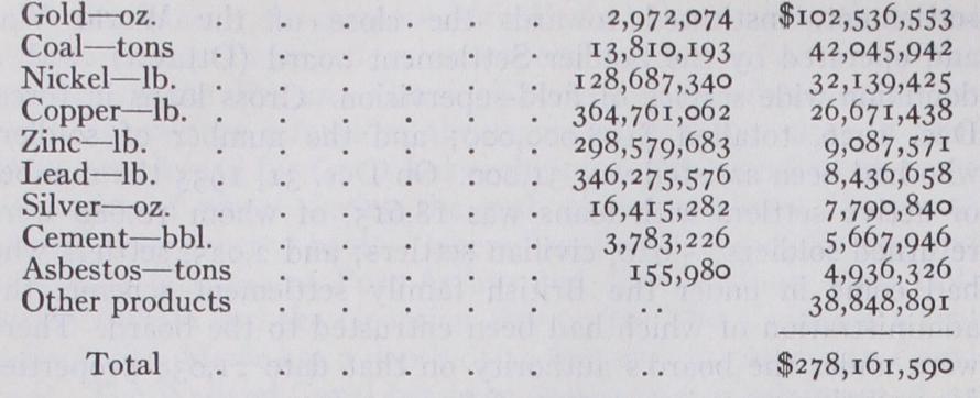
(3) The completion and stabilization of the scheme of soldier settlement, instituted towards the close of the World War and operated by the Soldier Settlement board (Ottawa), with a dominion-wide service of field-supervision. Gross loans in force, Dec. 1926, totalled $108,0o0,000; and the number of soldiers who had been assisted was 31,00o. On Dec. 31, 1935 the number of active settlers with loans was 18,615, of whom 10,68o were returned soldiers; 5,910, civilian settlers; and 2,025, settlers who had come in under the British family settlement scheme, the administration of which had been entrusted to the board. There were under the board's authority on that date 21,038 properties representing a net investment of (4) The growth of the tobacco industry in Eastern Canada, and especially in Western Ontario, under the stimulus of the 25% British preferential rate. Total exports of tobacco, 1922-$1 millions: 1935—$2a millions. Tobacco is more profitable than corn (maize) as a cash crop, and relieves the grower from the loss incurred by the ravages of the corn borer. Over 50% of Ontario tobacco is of the Burley variety, while in Quebec a corresponding percentage is cigar tobacco. One of the exper imental divisions of the Canadian Department of Agriculture is engaged in research upon the major problems of the culture, harvesting, and curing of tobacco. (C. R. F.) Minerals and Mining.—Most of the economic minerals occur in Canada, as might be expected from its great area and varied geology, and more than 6o products were reported in by the Dominion Bureau of Statistics; but only the more important need be referred to. Coal for many years stood first in value until in 1931 it was overtaken by gold. The estimated value of its output in 1935 was $41,888,533. Nova Scotia has bituminous coal of the Carboniferous age, more than half of which lies under the sea. Coke made from it and hematite, also mined beneath the sea in Newfoundland, make the basis of the important steel industry of Sydney. Alberta produces nearly as much coal, but of Cretaceous age and largely lignitic, though the quality improves towards the mountains. British Columbia mines less than half as much as Alberta, most of it Cretaceous, but some of it making excellent coke for the smelters.
Gold has been obtained in part from placer mines in British Columbia and Yukon Territory ; but at present it comes mainly from lode mines. Total production for 1935 was estimated at The Porcupine and Kirkland Lake districts in northern Ontario are the greatest producers, the Lake Shore mine in the latter region having a larger output than any other in Canada. Northern Ontario produced gold to the value of $78,127,817 in 1935. The silver mines of Cobalt, at one time the richest in the world, are becoming exhausted, so that British Columbia now leads in silver, which is obtained from ores con taining other metals. Copper is mined in large amounts in Ontario and British Columbia, usually in association with some gold and silver or lead and zinc in complex ores, which require elaborate plants for separating and smelting them. So% of the nickel of the world comes from the Sudbury district in Ontario, where it is associated with copper ore.
The literature on the geography of Canada is very scattered, but general accounts may be found in The Oxford Survey of the British Empire, vol. iv., and the Handbook of Canada, University of Toronto Press, 1924. The reports and other publications of the Geological Survey, Mines Branch, Topographic Survey, and Dominion Bureau of Statistics, etc., Ottawa, may be consulted for details.
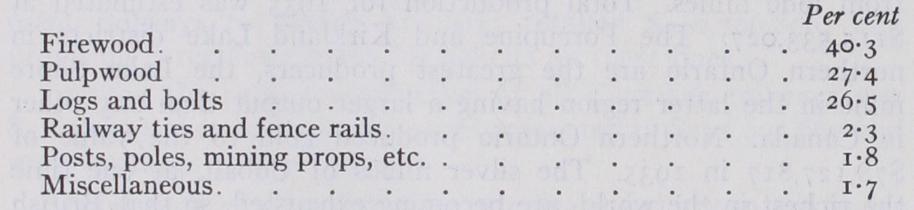
The average annual cut of timber from 1929 to 1933 was 2.47 billion cu. ft. The proportionate uses in 1933 were: Although it does not attract much attention, the humble woodlot leads in volume of wood produced. Pulpwood stands second in rank of production, but in value of its products, it far surpasses all others. The total value of all forest products in was 404 million dollars. The forest products are surpassed only by the agricultural as sources of wealth and in 1934 formed 16% in value of all manufactures. Much the greater part of the sawn lumber and the pulp and paper products is exported, chiefly to the United States. The export of the forest products on a valuation basis constitutes one-quarter of the total export trade.
In 1934, the date of the latest official figures from the Bureau of Statistics, the capital invested in the forest industries was 739 million dollars—about 184 millions in the saw milling and 555 million dollars in the pulp and paper industry. The two in dustries distributed 117 million dollars in wages to 114,000 em ployees in the forest and in the mills. The forest industries supply close to one-ninth of the total tonnage hauled by the railways.
Pulpwood is manufactured into wood pulp and paper. Wood pulp is only a stage in paper manufacture, but a mill may not carry the process to completion and a mill may not manufacture the pulp from which its paper is made. In 1934 there were 28 mills manufacturing pulp only, 24 mills making paper only and 43 mills producing both pulp and paper; 95 in all. Quebec ranks first among the provinces both as to the quantity and as to the value of wood-pulp produced, Ontario holding second place. Of the total paper manufactured in 5I% was made in Quebec, 3o% in Ontario, io% in British Columbia, and 9% in Nova Scotia and New Brunswick. Over 8o% of the paper manufactured is newsprint and over 91% of the newsprint is exported, chiefly to the United States.
At least two very important trends have manifested themselves in the forest industries in the past decade or two, the one, the shifting of the centre of the sawmilling production to British Columbia and the other the phenomenal development of the pulp and paper industry in eastern Canada. About of the total cut of sawn lumber and about 8o% of the shingles in 1934 came from British Columbia and this preeminence will doubtless con tinue for many years to come since that province possesses nearly half the standing saw-log material of the country. On the other hand the development of pulp and paper manufacture in the East appears from the fact that the value of these products rose from $92,000,000 in 1916 to $153,000,000 in 1934. Canada's average annual production of newsprint from 1929 to 1934 was over twice that of the United States and almost one-third of the world's total. (C. D. H.) Fur Farms.—Since the beginning of the century prices of the more valuable furs have increased with great rapidity as a result of a decrease in supply and an increase in demand. This has been the cause of numerous regulations on the part of the prov inces and the Dominion, leading to the conservation of fur-bearing animals. Fur-farming, especially with silver and black fox in Prince Edward Island, has become an important industry since 1910. During the World War the European market was shut off and North America developed its own marketing system. In Canada auction sales are held at Montreal, Winnipeg, Edmonton and Vancouver. Manufacturing of fur goods also received an impetus from the war. In recent years the provinces of Quebec and Ontario have surpassed Prince Edward Island in the value of their fur farms.
According to the last available census, that of 1933, the ten leading manufactures judged by value of products were: Value of Products Pulp and paper $123,415,492 Central electric stations . . . . . . 117,532,o81 Non-ferrous metal smelting 100,561,297 Slaughtering and meat-packing 92,366,137 Flour and feed mills . . . . 83,322,099 Butter and cheese . . . . . . . Petroleum products . . . . . . . 70, 268, 265 Bread and other bakery products . . . . 51, 244,1 62 Cotton yarn and cloth 51,179,628 Printing and publishing 50,811,968 While the chief industries are directly dependent upon native resources, four virile industries, manufacture of automobiles, cotton goods, sugar and rubber goods, utilize materials largely imported in a raw or semi-finished state.
Since 1879 the state has sought to promote manufacturing by protective tariffs and in some cases by bounties and subsidies. At intervals the municipalities have also assisted manufacturers by exempting them from taxation or by granting loans and bonuses, a practice at one time very common in Ontario. The Canadian protective tariff has never been high. The average ad valorem rate of duty reached its peak in 1889, when the rate was 31.9%. In 1935 it was 28.1%. Its precise stimulus is diffi cult to determine, because of the mass of influences on the growth of industry and the impossibility of isolating the effect of each. In the 20th century, tariff or no tariff, Canada's manufactures grew rapidly with the opening of the West, the extension of rail ways, the growth of population, the development of mineral and forest resources, and the discovery of vast power in the country's extensive waters. Utilization of water power has become a vital fact in her industrial life.
The dominion has about 20.3 million horse-power at ordinary minimum stream flow, rising to over 33.6 millions for at least six months of the year. The central provinces without indigenous coal supplies have steadily endeavoured to utilize this power for manufacturing although up to the present more than 18% of the recorded water power resources have been harnessed. Of the total electric output of Canada about 98% is generated by water power, and almost half the primary power used in manufacturing industries other than central electric plants is hydraulic. In the installed electric capacity of the central power stations was h.p., while the installed equipment for non-electric power in manufacturing establishments was only 1,477,741. The industry which has benefited most is woodpulp and paper. Since the beginning of the 20th century, it has grown phenomenally be cause of the country's great timber resources, an ever widening . market for newsprint, and the cheap power obtained from Can ada's many waterfalls.
Manufactures are not evenly distributed throughout the dominion. About 8o% are concentrated in the provinces of Ontario and Quebec. Ontario alone contributes nearly 50% of the net manufacturing output of the country. Such concentration is due to the nearness of the older provinces to water and mineral resources, proximity to the coal fields and the industrial belt of the United States, and the possession from early times of large populations. An important effect of the regional massing of manufactures is an acute conflict of political interests between the eastern and western provinces.
While Canada continues to export large quantities of raw products, there is an increasing proportion of native products exported in manufactured or semi-manufactured form, an ex pressive result of the country's industrial progress. Another indi cation of such progress is that the percentage of raw materials imported has steadily risen since 1900. In the latter year raw materials represented 24.9% of total imports. In 1935 they had climbed to 3o.4%. Twelve of the principal imports, arranged in the order of their value in 1935 are: coal, crude petroleum, automobile parts, rolling-mill products, fruits, machinery (not including farm implements), raw cotton, sugar and sugar prod ucts, alcoholic beverages, cotton goods, woollen goods, and rubber products. Machinery and iron and steel products hold a prominent place in the list of Canadian imports because of the constant demand in the extractive industries and the inability of domestic plants to meet it. The dominion has large deposits of iron ore, but with few exceptions they have not been developed commercially, and ore is imported from the Wabana mines in Newfoundland and from the United States.
In the years from confederation to 1935, exports have exceeded imports on 30 occasions, while imports have exceeded exports on 38 occasions, but throughout the period as a whole there has been an excess of exports over imports. The "unfavourable" balances occurred in years of heavy capital imports, as notably in 1903-13. The "favourable" balances represented Canada's successful meet ing of foreign obligations.
The federal government has done much to promote foreign trade, and particularly to assist the Canadian exporter to procure markets abroad. The Department of Trade and Commerce estab lished the Commercial Intelligence Service, and a leading part of its programme is the appointment of commercial agents and com missioners to report upon the demand in foreign countries for such commodities as Canada is in a position to supply. A Com mercial Intelligence Journal is published weekly, and distributed among firms engaged in export trade. The government also en deavours to encourage trade by the negotiation of commercial treaties with foreign states. Boards of trade and chambers of commerce in cities and towns play an important role in investi gating the possibilities of distant markets, and the nation-wide Canadian Manufacturers' Association interests itself in the same end. The leading Canadian banks by establishing branches abroad have similarly done much to promote external trade. (A. Bit.) Education.—For details of Education in Canada see the sec tion on this subject in the article British Empire.
Anthropologically as geographically, Canada must be considered as an integral part of the North American continent. The bound aries between the Dominion and the United States, Alaska and Newfoundland do not conform to ethnic divisions among the aborigines. The culture of the Canadian natives does not differ markedly from that of their neighbours.
The first explorers found the country inhabited by people of brown complexions, lank hair and primitive mode of life to whom the term "Indian" was applied. In later years the same designa tion was given to the various tribes encountered by adventurers, French and English, as they penetrated westward across the continent. In the north, however, the hunters dwelling on the shores of the Arctic were so different both in appearance and culture that the term "Indian" was inapplicable, and "Eskimo" was used instead.
Certain important physical characteristics are common to all Canadian Indians. The colour of the skin is dark brown—"red" is a misnomer and "yellow" an exaggeration; the black hair is leiotrichous (smooth) ; the zygomae (cheekbones) are prominent; the face is broad in comparison with the breadth of the head; the nose is usually well developed, though not flattened ; the in cisors are often concave, and the frontal portion of the skull is somewhat ill-filled. But it must be emphasized that there is no absolute uniformity of type. On the coast of British Columbia the natives are characterized by relatively short stature, heavy build, with round heads, broad faces and a certain amount of facial hair. On the Plains the stature is greater, the body more lithe and grace ful, facial hair limited to an occasional sparse moustache, and the head form ranges from medium to low broad types. The Eastern type generally resembles that of the Plains, although several tribes have longer heads, and a few prehistoric dolichocephalic skulls have been found.
The Indians of Canada belong to one racial stock, related to the Mongoloid branch of mankind. An unmixed race does not ex ist in North America, and the physical differences in America sug gest that the migrations from Asia came in successive waves, comprising non-homogeneous Mongoloid groups. Furthermore, environmental factors have probably produced considerable vari ation within America itself.
It is difficult to estimate the antiquity of man's settlement in America. Goddard (American Anthropologist, vol. xxix., 1927, p. 262) has recently summarized the evidence for human existence during interglacial periods, but Hrdlicka and other students hold that the continent was uninhabited until post-glacial times. It is probable that the ancestors of the Indians came by the north western route across Bering strait. Even at the present time the passage occasionally freezes so solidly that it is possible to walk from Asia to America, while the Diomede islands offer conveni ent stepping-stones for sea voyagers. The earliest immigrants were probably long-headed or dolichocephalic (possibly akin to the Palaeo-Amerinds of Haddon) ; the length of the skull among some of the Iroquoian and Algonquian peoples of Ontario may be either a survival of this characteristic or a mere deviation from the later and now predominant round-headed type. Norsemen undoubtedly reached the eastern coast, but have left no impress on the physique of the people. Other maritime adventurers had little effect upon Canada.
The Eskimo (q.v.), who inhabit the shore of the Arctic from north-west Siberia to Greenland, present an appearance very dif ferent from that of the Indians. Their hair is equally straight, but the skin colour lacks the warm brown of their southern neigh bours. The large, long head is high, somewhat keel-shaped in general form ; the nose is narrow and inconspicuous, which, com bined with prominent cheek-bones and unusually broad face, gives a frontal appearance of flatness; the eyes are black with the epi canthic fold frequent ; the hands and feet are even smaller than those of the Indians, and the stature usually less. These char acteristics are most obvious in the Hudson Bay region ; towards Alaska mixture appears to have taken place and the head is broader. The smooth hair and broad cheek-bones, however, indi cate membership in the same general Mongoloid race, of which they may be regarded as a highly specialized offshoot. Sollas (Journal of the Royal Anthropological Institute, vol. lvii., 1927, p. 89) contends that they resemble the Chancelade type of Mag dalenian Europe. At that period conditions in France resembled those under which the Eskimo now live, and it has been sug gested that their ancestors slowly followed the retreat of the ice, later spreading along the shores of the Arctic, either by way of Asia or Greenland.
The presence of a large number of closely related and inter mediate types prevents a rigid and satisfactory classification of the Indians by physical means alone, so other criteria must he employed. Linguistically, the tribes of Canada and Newfound land can be divided into the following stocks:— (I ) Beothukan.—Little is known concerning the speech of the extinct Beothuk of Newfoundland, but limited vocabularies indicate that it was unrelated to any other known language.
(Io) Athabascan (q.v.).—Athabascan-speaking bands—their political organization is too intangible to warrant the name of tribe—rove over the vast regions of the Yukon and Mackenzie 'In this article the spelling follows that adopted in Handbook of American Indians (Bulletin 3o, Bureau of American Ethnology, Washington, 1906).
basin, eastward towards Hudson bay, generally north of the Al gonquians. Southward they extend into the interior of British Columbia, coming in contact with the coastal tribes on the west and the interior Salish on the south. Other Athabascan groups, widely separated from their northern kinsmen, are found in Ar izona, New Mexico and Mexico, while on the Canadian Plains the Sarsi are confined to a reserve near Calgary.
(I I) Eskimo.—The Eskimo language, comprising several dia lects, is spoken along the Arctic coast from Siberia to Greenland. Scattered settlements dot the whole shore of the Canadian Arctic, with the exception of the southern part of Hudson bay, and extend down the Labrador coast almost to Belle Isle.
The Indians are undoubtedly proud, and their reaction to the attitude of superiority assumed by the white man is to withdraw into a shell of grave and dignified reserve which has been misin terpreted as taciturnity. Among themselves, the natives are as fond of laughter and joking as any other people. Their behaviour in times of joy, sorrow, fear, excitement or periods of stress is far from one of indifference, although pride leads them to conceal their emotions. The Iroquoian peoples and the Plains tribes respect martial achievement and fortitude in pain, but oratorical ability, skill in hunting, athletic prowess, wealth (on the Pacific coast), wisdom, religious power and other characteristics are also esteemed. Individuals vary, but their fundamental psychology is not radically different from that of white people, although the medium in which it is expressed—their culture—appears so strange to the European that the underlying qualities are usually mis understood.
In material culture the wheel was unknown ; the use of metals was limited to the beating out of unrefined copper; the dog was the only domesticated animal; and, north of Mexico, there was no system of writing. Stone was universally used for tools, fre quently ground or polished to a smooth surface. Work in wood, bone, shell and ivory varied from area to area, dependent largely on local conditions.
Climate, flora, fauna and geographical considerations have pro foundly affected the life of the aboriginal Canadians. The cul ture of tribes living within given zones tends to conform to a type, irrespective of linguistic or physical classifications. On this basis the following areas can be distinguished:— (I) The Arctic Belt.—The Eskimo (q.v.) of the Arctic islands and littoral differ from the Indians as markedly in culture as in physical characteristics or language. The keynote of their exist ence is dependence upon sea animals. Wild-fowl, rabbits, bear and caribou are hunted during the brief summers, but seals and whales are more important than any of these. The flesh is eaten, and the grease serves as fuel for the indispensable stone lamp used for heating and cooking during the winter. Wood is ex tremely scarce, but the Eskimo are skilful workers in bone, ivory and, to a lesser extent, stone. Their chief weapons are lances and harpoons, the latter fitted with detachable head and fore-shaft. The bow is composite, made of bone and drift-wood, elasticity being obtained by thong lashings. Similar ingenuity is shown in other Eskimo manufactures. Stone and, in the Coronation Gulf area, copper tools are set in bone handles; the bow-drill is used for perforating hard objects; well-tailored fur clothing is made; toys and toggles are carved of walrus ivory, and the vaulted snow house is a unique architectural achievement. The hunter's canoe is also distinctive, consisting, as it does, of a bone or a wooden framework over which a waterproof skin cover is stretched.
Eskimo political organization is limited to the simple band, comprising a number of related families. Such a group wanders over a vaguely defined area, returning year after year to the same camping-grounds following the movements of game. The leader is the most skilful hunter, but he is entirely without authority, and hereditary chiefs with executive or judicial power are un known. Shamans have much influence, especially with regard to the enforcement of multitudinous hunting taboos, but there are few communal religious rites.
The north-eastern Algonquians in Quebec and Labrador, are the Montagnais (q.v.) and the Nascapee.
The culture of the Iroquoian-speaking (see IRoQvors) tribes of southern Ontario, the Hurons (q.v.), the Neutrals and the To bacco Nation differed fundamentally from that of the Algon quians. Large crops of corn, beans, squashes and sun-flowers pro vided reliable food stocks and made possible the erection of vil lages which were moved only when the fields became exhausted. Communal houses were built; wood and bark were used for uten sils, as was also rough pottery to some extent.
Chiefs, elective or hereditary, formerly exercised great author ity, but martial achievement often enabled a man to attain a su perior position. Male societies still flourish, their members exer cising functions of a war-like, political, economic and social nature.
Success in life was usually attributed to the aid of a guardian spirit, acquired at adolescence. The collection of certain sym bolic objects was sometimes recommended in a dream or vision, and these, carefully preserved, often for generations, served as tangible articles of religious veneration. Intangible prerogatives are frequently closely associated with them. Socio-religious rites are extremely important on the Plains, the scattered divisions of a tribe assembling annually for the performance of elaborate symbolic celebrations, of which the Sun Dance is the best known.
The staple food supply of this area is the caribou ; deer, rabbits, wild-fowl, fish and berries are eaten when obtainable, but, espe cially in the north, the roving hunting bands depend on the cari bou. The toboggan simplifies transportation in winter, the canoe and the dog-drawn travois in summer; but life is hard at the best of times. Material culture is scanty; pottery is unknown; bark vessels are used for cooking ; baskets are plaited of spruce-roots; clothing was formerly of skins; and one of the few distinctive traits of culture is the double lean-to. The Athapascans are un usually receptive to foreign influence, and have assimilated many elements from south and west.
The political organization of the eastern Athapascans comprises only the simple band, a loose-knit, patrilineal unit without def inite leadership. The men have the reputation of cowardice, the women of immorality; exchange of wives takes place, and wres tling duels for women are reported. The settlements of the western Athapascans are semi-permanent, matrilineal clans are found among several of the tribes and chiefs have greater authority. The western shamans are said to have added the function of confess ing to the powers claimed by their eastern prototypes.
(6) The Interior Area of Southern British Columbia.— The wooded valleys of southern British Columbia are inhabited by the Kutenai and the Salish-speaking Thompson, Shuswap and Lillooet. The rivers flowing westward are filled every year with salmon, which the natives formerly caught in large numbers and smoked or pulverized for winter use. Deer and mountain goats were hunted and berries collected in large quantities. Clothing was of deer-skin, while rabbit-skin blankets were woven prior to the introduction of European goods. Wood was used more ex tensively than on the Plains, including a kind of slat armour. Pot tery was lacking, but excellent basketry is still produced, including water-tight vessels ; twine weaving was employed for bags. Rush covered lean-tos served for shelter, replaced in winter by per manent, semi-subterranean houses with combined door and flue.
Semi-hereditary chiefs, exercising considerable influence over local groups, formerly prevailed, but they lacked the martial prowess of their compeers on the Plains, or the respect based upon wealth as among the coastal groups. Ceremonial rites were also weakly developed, although puberty ceremonies were performed, and the Kutenai held an elaborate ritual before departing to the Plains on their annual bison hunt. In addition to guardian-spirits, there was a belief, among the Kutenai at least, in the sun as a vague supreme being. The culture of this area is, in many respects, intermediate between that of the Plains and the Pacific littoral.
Political organization is marked by the importance of hereditary rank. The Haida and the Vancouver Island Salish have four classes, chiefs, nobles, commoners and (formerly) slaves, each stratum being, in theory at least, endogamous. These distinctions are less rigid in the central sub-area, where, however, great def erence is shown to the man who is able to display his wealth by a lavish bestowal of goods to validate the assumption of prerog atives. The strongly organized northern tribes are matrilineal, the southern are patrilineal ; in the central region the influence of the former has led to the introduction of certain matrilineal institutions. Secret societies, employing masks and ingenious me chanical devices, further complicate social life. There is a firm belief in supernatural beings, whom the Bella Coola have organ ized into a pantheon, dominated by a supreme deity.