
CENTRAL AMERICA, geographically that portion of the American continent lying between the Isthmus of Tehuantepec in Mexico, and the Isthmus of Panama, or Darien, in the republic of Panama; politically, the five republics of Costa Rica, Nicaragua, Honduras, Salvador and Guatemala, and the British crown colony of Belize, or British Honduras. The geographical division is com monly known as "the isthmus," lying as it does between the nar rowest portion of Mexico (Tehuantepec), immediately north of which Mexico broadens to continental proportions, and Panama, the narrow neck of land now cut by the canal, immediately south of which Panama and then Colombia broaden into the South American continent. The political delimitation of Central America, that is, the giving of the name to the five republics and British Honduras, is based, like most of the present boundaries of Span ish America, on the old Spanish colonial administrative areas. Central America is now, roughly, what was comprised in the cap tain generalcy of Guatemala, on the north of which was the viceroyalty of Mexico, or New Spain, and on the south the viceroyalty of Nueva Granada, out of which have since been carved Panama, Colombia, Venezuela and Ecuador. The inclusion of Panama in Central America, while now common, is the result of a loose lumping of the smaller Caribbean republics of the isthmus into one group in our common thinking, but Panama was never politically associated with the Central American countries and until 1903, indeed, had no political life separate from Colombia. Geologically and climatically, however, Panama might properly be included in Central America, owing to the fact that the geographical division which is called "the isthmus" is thus, also, the natural geological and climatic unit.
Central America, as politically delimited, lies between 8° and 18° 3' north latitude and between 82° 50' and 92° 17' longitude west. The easternmost point of Central America is thus almost directly south of Florida, in the United States, and the most westernly point is almost directly south of Galveston, Texas. The northern boundary is Mexico for a portion of the distance (north of Guatemala and British Honduras), and the Caribbean sea for the long northern boundary of Honduras. On the east is the Caribbean and on the south and west the Pacific ocean. British Honduras stands vertical, north and south, along the eastern edge of the almost uninhabited wilderness of Peten, in Northern Guatemala, once the seat of the great "old" Maya empire, and the British colony faces on the Caribbean. The five republics, on the other hand, trail off from north-west to south-east, some 600m. long and 25om. wide at their widest point (between the north-eastern corner of Honduras and the south-western coast of Nicaragua). The longest straight north and south line in the entire isthmus is between the northern coast of Honduras and the peninsula of Nicoya in Costa Rica, about 45om. The total area is approximately 185,000 square miles.

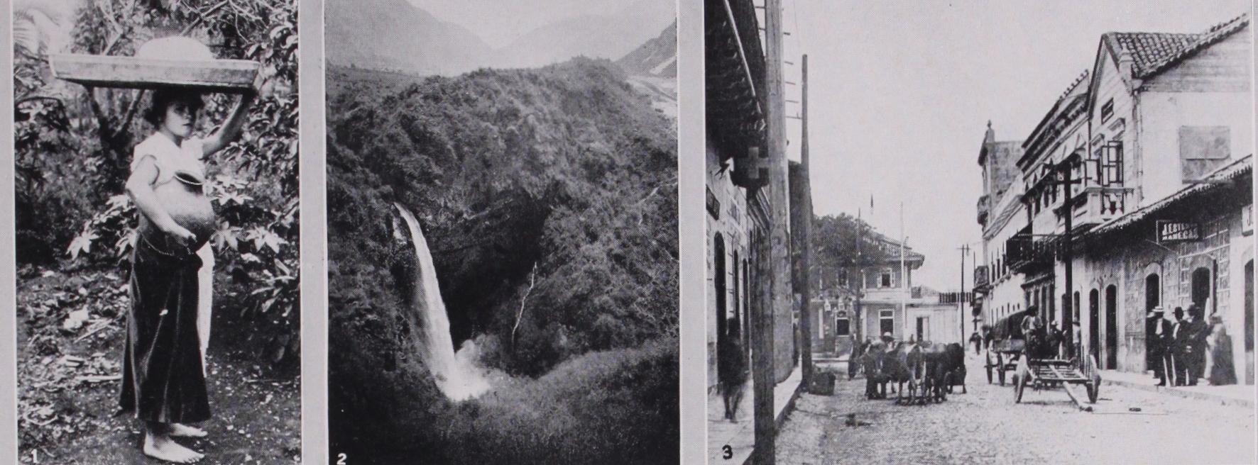
Central America boasts the largest lake south of the great lakes of Canada and the United States, and north of Lake Titicaca in Peru and Bolivia. This is Lake Nicaragua, Isom. long by 45m. wide, while Lake Managua, 38m. long by 16m. wide, is connected with it by a short river. Salvador has a number of beautiful lakes as has Guatemala, Lake Atitlan being one of the most beautiful spots in the Central American mountains. The rivers on the Pacific side are most of them short and swift, as the coast is nar row, the Lempa, in Guatemala, Honduras and Salvador being the most important. On the Caribbean side the rivers are longer and more important, the Segovia or Wang being some 45om. long. The Caribbean coast is marked by lagoons and great bays, which are virtually landlocked salt water lakes. (W. THo.) Geology.—The trend of the structural lines in South America is not continued in Central America, where the strata are bent into folds whose axes extend nearly east and west. The mountain ranges in Central America are therefore assigned to what is called the Antillean system, as distinguished from the Andean system. Two submarine ridges that extend across the Caribbean sea, one between Honduras and the Sierra Maestra range in Cuba and the other between Cape Gracias a Dios and Jamaica, are regarded as submarine Antillean ranges. An exception to the general eastern direction of the folding is seen in the depression that crosses Honduras from the Gulf of Fonseca to Puerto Cortes, where the trend of the folding is generally northward. This depression may be a trough formed by faulting.
In Guatemala there is a group of eastward-trending ridges composed of old granite and schist, and areas of similar rocks, presumably Archaean or Palaeozoic, are found in British Hon duras, Honduras and Costa Rica. In Guatemala these old crys talline rocks are at some places overlain by beds of Carboniferous limestone. The oldest Mesozoic rocks are some isolated beds of sand and clay, possibly of Triassic age, containing the remains of plants. Large areas of Cretaceous clay, sandstone and conglomer ate and an overlying series of beds of limestone are found in Guatemala, Honduras and Costa Rica. The Tertiary rocks, which are widespread, may be divided into two parts. The lower part consists of Eocene and Oligocene beds, chiefly sand and clay, which were evidently laid down in shallow water, near the shore. The upper part includes Pliocene beds, which were also laid down mainly in shallow water.
All the beds up to those of the Oligocene series are involved in the structural folds. The Pliocene beds are generally undis turbed. The Miocene epoch appears to have been a time of uplift and great disturbance throughout the Caribbean region. The two continents were probably brought together by the Isthmus of Panama during that epoch. The record disclosed by a study of the fossils of North and South America confirms this conclusion. It shows that the mammals of South America in middle Tertiary (Oligocene) times included none of those that then inhabited North America. The South American mammals of this time included armadillos, sloths, ant bears and a number of peculiar rodents, among them the water hog, the largest rodent known, none of which are represented by middle Tertiary fossils found in North America. The middle Tertiary North American mam mals, on the other hand, included several species of deer, wild hogs, wolves, rabbits, squirrels and other well-known animals. The deposits of late Tertiary (Pliocene) times of both continents, however, show a mingling of animals belonging to both groups, confirming the conclusion indicated by the geologic record—that the two continents were joined late in Miocene times by an uplift of the land that made possible the migration of animals from one to the other. Further confirmation of this conclusion is found in the results of the studies of the sea fishes on both sides of the Isthmus of Panama, which show differences indicating a separation of the fishes in Miocene times.
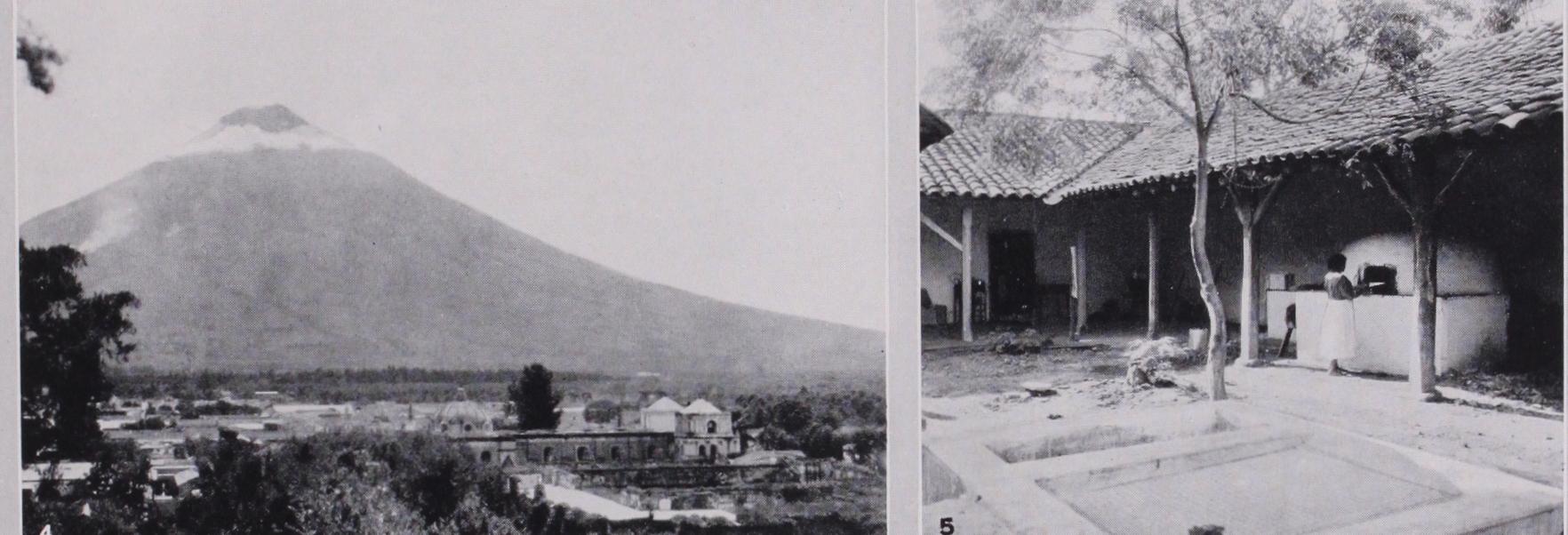
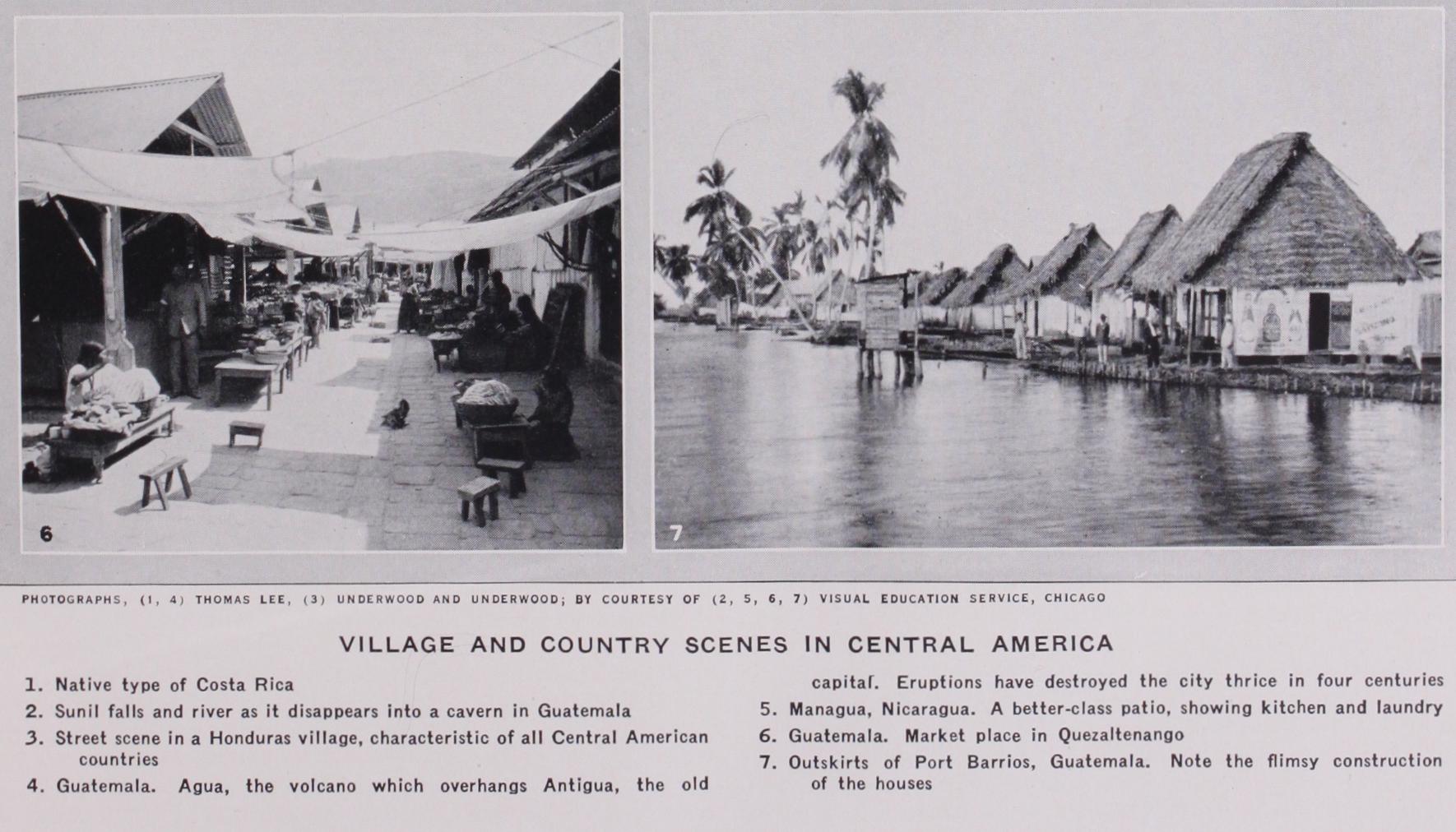
The volcanoes in Central America stand along the west coast. The volcanic deposits are extensive and deep. The eruptions began near the end of the Cretaceous period and still continue intermittently. The eruptive lavas and ashes are mostly andesite and basalt but include also rhyolite and trachyte, and, at a few places, some phonolite. (G. McL. Wo.) Population.—The total population of Central America (ex cepting British Honduras) as estimated by official bureaux of the government of the countries, is 5,965,913. Its composition is varied, from virtually pure-blooded Spanish whites on the high lands of Costa Rica to a mixture of Indian and negro which calls itself "Carib Indian" on the Caribbean coast of Nicaragua, Hon duras and Guatemala (see Ethnology, p. 128).
Central America was discovered by Christopher Columbus himself on that last fateful voyage when he drove desperately westward from the Caribbean islands in a determination to find the strait to the China seas which he believed existed just beyond the barrier of the great continent that he had revealed to the world. He skirted the coast of Central America for virtually its full length, exploring the inlets and the immense lagoons, to the greatest of which his own crew gave a name in his honour—the Laguna del Almirante ("the Lagoon of the Admiral"). On this voyage, in 1502, Columbus founded in Costa Rica, the first colony in Central America, leaving his brother Bartholemew, in com mand, but the Indians, whose gold ornaments had been accepted by the Spaniards as assurance that gold was abundant there, quickly dispersed the colony and its survivors rejoined Columbus. No rich source of the gold of these ornaments—rare archaeological treasures to-day—has ever been found in Costa Rica, and the absence of treasure in Central America was doubtless largely responsible for the fact that Central America was not the subject of spoliation. Its location close to what was to become the chief route of shipment to Spain of the treasures of Peru and of the Orient, made its control and its wise political administration im portant in the eyes of Madrid.
Guatemala was conquered by Pedro de Alvardo, as lieutenant and representative of Hernando Cortez, who himself led his army for part of the way from Mexico through the jungle wilderness in 1522 and 1523. Alvarado was opposed by the highland Indians, and a terrible battle was fought not far from Quezaltenango be tween the Spaniards and the Indians under Tecum, resulting in a defeat of the Indians which was apparently decisive. Costa Rica was conquered in 1513 by Pedro Arias de Avila, but the entire region from Mexico to Panama was made a portion of the vice royalty of New Spain or Mexico, and after its organization as a captaincy general Costa Rica was included in the administrative unit. The conquest of the other Central American provinces was largely perfunctory, little opposition being encountered excepting on the Caribbean coast, where the Carib Indians were virtually exterminated.
The captaincy general of Guatemala, including all of present day Central America and a portion of Mexico, declared its indepen dence of Spain, with little bloodshed, on Sept. 15, 1821, and almost immediately thereafter came under the domination of the Emperor Iturbide of Mexico, and was part of his empire. The overthrow of the Mexican empire, however, returned the autonomy of Central America to its own people, the Mexicans retaining the former Guatemala territory now incorporated in the recognized national boundaries, long regarded as a Guatemalan "irredenta." Central American Union.—On July 1, 1823, the first Central American union was formed, comprising the five old Spanish provinces, now Guatemala, Honduras, El Salvador, Nicaragua and Costa Rica, the only boundaries between the provinces and between Central America and the outside, being those of the old Spanish administration ; Belize had been occupied by British traders engaged in the hardwood lumber trade since the 1 7th century, and the eastern coast of Nicaragua was practically a British protectorate, under the name of "the Mosquito kingdom." By the Clayton-Bulwer treaty of 185o between the United States and Great Britain, Belize was recognized as a British possession and became British Honduras, while the protectorate of the Mos quito coast was surrendered by Great Britain and the territory reverted to Nicaragua. The boundary between Costa Rica and Colombia was then, and continued until 1921 (when the con troversy was, of course, between Costa Rica and Panama) to be in question, the settlement by Chief Justice White of the U.S. Supreme Court, confirming the earlier decision of the king of Spain, being accepted that year. The Mexican boundary and that of British Honduras, while somewhat vague in actual location, owing to the undeveloped condition of the country, were firmly established along parallels of latitude or degrees of longitude.
The first Central American union, as formed in 1823, was dominated by the conservative elements of Guatemala, including the clergy and Spanish administrators, and this domination proved irksome to the elements which, distant from Guatemala, had a more liberal idea of the independence and its potential possibilities for themselves. The first opposition to this union broke out in Honduras, where the Federalist or Liberal party had grown power ful and had evolved strong leaders. Since that date, the political parties of all the Central American countries have sprung from these two parent stems, and continue the use of the names Con servative and Liberal. Thus, even to-day, it may be safely said that the Conservatives of any one of the countries are closer to the Conservatives of the other countries than they are to the Liberals of their own country, the same being true of the Liberals. The complicated politics of Central America, with its wars and revolutions, are understandable only if that fact is remembered and counted upon.
The bitter struggle which began in the '2os continued finally under the leadership of the great Guatemalan Conservative Rafael Carrera, and the equally able and more spectacular Liberal leader of Honduras, Francisco Morazan. Morazan was finally de feated and executed in 1842, and the federal union, which he had made his battle-cry, was dissolved. A union dominated from Guatemala was formed in the same year but without Costa Rica. This dissolved in 1845, and in 185o Honduras, Salvador and Nicaragua formed another union which was broken up by the Guatemalans under Carrera, as being a threat against the auton omy of that country and the power of the Conservative party.
The battle for the union was the occasion of the landing in Nicaragua in 1856 of the American filibusterer, William Walker (q.v.), who joined forces with the Liberals in the struggle for the control of Nicaragua and was for a time the Liberal presi dent of that Republic, and was attacked by the Conservative forces of all the countries of Central America, ultimately suffer ing defeat and death at their hands.
The efforts to form the Central American union lapsed after about 186o, until 1876, when Justo Rufino Barrios, the great Liberal leader of Guatemala, endeavoured to revive the old federal union, under various plans. He was killed in battle in 1885, in the course of an invasion of Salvador, then ruled by the Con servatives, in a final effort to impose the union by force. Futile efforts at union were made in 1887, 1892, 1895, 1897 and 1898.
In 1902, a move of considerable significance in Central American history took place at Corinto, Nicaragua, when representatives of Costa Rica, Nicaragua, Honduras and Salvador drew up a treaty creating a tribunal of Central American arbitrators for the pacific settlement of international disputes. Four years later, a dispute between Guatemala and Salvador reached a point where war was avoided only by the intervention of President Roosevelt of the United States and President Diaz of Mexico. This was followed by a conference on the high seas aboard the U.S. cruiser "Marblehead," one of the shortest and most effective peace con ferences on record and known in Central America as the "Peace of the mal de mer." As a result there was drawn up in San Jose, Costa Rica, on Sept. 15, 1906, a new treaty between Costa Rica, Honduras, Salvador and Guatemala, under the provisions of which the presidents of the United States and Mexico were agreed upon as umpires in any future international disputes between the signatory nations.
Nicaragua was not a party to the San Jose pact, and its presi dent, Jose Santos Zelaya, declined to join in it. Therefore, in 1907, when Zelaya became involved in a controversy with Hon duras over revolutionary activities in the ill-defined borderland between the two countries, Nicaragua offered to arbitrate under the Corinto plan before a commission of Central Americans, while Honduras was willing to arbitrate only under the San Jose plan, before the presidents of the United States and Mexico. No arbi tration was taken, therefore, and the situation grew more serious, involving Salvador and threatening to involve Guatemala. The ultimate result was the mediation of the United States and the calling of the first Central American conference at Washington, which met on Nov. 13, 1907, representatives of all five of the republics being present.
The conference resulted in the signing of a general treaty of peace and amity, including a provision that recognition should be withheld from revolutionary governments until the country suffer ing the revolution had been reorganized by constitutional means. It also resulted in the creation of the Central American court of justice, to be located at Cartago, Costa Rica, and to be formed of judges named by the five countries, sitting virtually continuously or subject to immediate call to settle all questions which diplomacy should fail to resolve, and to determine cases involving alleged denials of justice to private citizens of one country by the courts of another.
In the controversy before the Central American court Nicaragua held that its treaties and relations with other powers were not subject to the scrutiny of the court, and when defeated in this stand, by a vote of four to one, withdrew from the court, and shortly thereaf ter the court ceased its functions.
At this juncture, a second Washington conference of the Central American States was called, 'which met on Dec. 4, 1922, and ad journed on Feb. 7, 1923. The American secretary of State, Charles E. Hughes, presided personally at all the sessions, and the 14 treaties and conventions then drawn up were signed by all the countries, and one of them (providing for commissions of in quiry as a basis for arbitration) by the United States as well. The 1923 conventions and treaties were regarded in Washington as destined to clear the troubled political waters of Central America, but none of the five countries ratified all of the treaties, and those still unratified include that providing for commissions of inquiry, the only one to which the United States is a signatory. The gen eral treaty of peace and amity, signed by all the countries, went further than that of 1907 and provided that the nations would not recognize rulers in the other nations who had come into power by a revolution or coup d'etat, nor the succeeding governments, even if installed as a result of an election, if the head of the State was a leader, or a close relative of a leader of the revolution or coup d'etat. The department of State of the United States, in connection with its efforts to forestall the Honduran revolution of 1924, issued a note to the contending parties in Honduras (and caused it to be sent to the foreign offices of the other Central American countries) to the effect that while not a signatory to this treaty, it would follow this test of legitimacy in according its own recognition to new governments in Central America.
The political developments in Nicaragua following the with drawal of the American marines in 1925 (see NICARAGUA) were based in part on the literal support of Washington of this policy, and this in turn has brought forward the criticism that with Washington's effort to eliminate the right of revolution as the escape-valve of oppressed peoples, there should go a correspond ing provision, by Washington, of the assurance of fair elections at which the majority might express itself, and that Washington should support the legitimate succession when imperilled. The former dictum was accepted by Henry L. Stimson, the investi gator sent by President Coolidge in 1927, and an election guarded by U.S. marines was assured for 1928, but the policy of support ing legitimate governments was declared an impossible develop ment of the situation enunciated in the case of Washington's re fusal of aid to Vice President Juan B. Sacasa when he was driven out of Nicaragua by the Chamorro revolution in 1925.
Two of the countries, Guatemala and Costa Rica, have trans continental railway systems. Practically all the commercial rail ways in Central America are 36in. gauge. One country, Honduras, has only one general commercial line, the others being owned and operated by banana companies on the Caribbean coast. Nicaragua has only one railway, paralleling the Pacific coast, from the port of Cortino to Leon, Managua and Granada. Salvador and Guate mala have comparatively adequate railway systems, all—excepting the British-owned line from San Salvador to Acajutla in Salvador —owned by the International Railways of Central America, a United States enterprise.
The highway development of Central America, while not so rapid, even proportionately, as in South American countries gen erally, is advancing steadily. Salvador is the most advanced, a nation-wide system having been planned in 1926 and being now steadily under way. Guatemala is second, with a fairly general highway plan, partially executed. Honduras has depended more on highways than have the other countries, and has a magnificent and extremely expensive road from the Pacific port of Amapala (San Lorenzo on the mainland is the terminus of the highway) to Tegucigalpa, and the through road to the Caribbean coast, by highway and lake boat, to the head of the National railway at Portrerillos is now open most of the year making automobile traffic comfortable.
Nicaragua has suffered more than any of the other countries from lack of adequate communications, and excepting for the highway from Managua to Matagalpa, open during the dry sea son and usually passable in the wet season, has been almost un developed. On the Atlantic and Pacific sides, the lack of rock for road construction has been a serious obstacle, and in the mountains the absence of settlements has made the construction of roads expensive in proportion to their benefit. The railway to the Atlantic coast has long been an unattainable ideal, and ade quate highway development a serious government problem. Costa Rica, with its transcontinental railway system, has been virtually without feeder railways or roads, and concentration of the life of the country on the plateau has been a necessary result. It has planned an adequate highway system, but so far development has been slow.
The opportunities for the development of Central America have always seemed tempting, and British and German capital has found a ready investment as has, in more recent years, American capital, in increasing amounts. The lack of abundant labour sup plies has been a deterrent to Central America's economic develop ment, but the proximity of the producing regions to the long coastline and the possibilities of machine development of the agricultural resources have been tempting. Little mining has been done on a large scale, owing to the character of the country, which has few mineralized sections, and these not of great rich ness. The chief importance of Central America as an economic unit seems to be derived from its proximity to the Panama canal, and from the possibility of the building of another canal through Nicaragua, placing the countries close to the interest and possible economic development of the United States.
BIBLIOGRAPHY.-H. H. Bancroft, History of Central America (1883Bibliography.-H. H. Bancroft, History of Central America (1883- 90) ; Stephen Bonsai, The American Mediterranean (1912) ; Chester Lloyd Jones, Caribbean Interests of the United States (1916) ; Dana G. Munro, The Five Republics of Central America (1916) ; L. E. Elliot, Central America (1924) ; W. S. Robertson, History of the Latin American Nations (1925) ; Wallace Thompson, Rainbow Coun tries of Central America (1926) ; G. Reginald Enock, Central and South America. Compare also the following: A Central American League of Nations (Part III. of a trilogy on "The New Pan-Ameri canism") World Peace Foundation, Boston, 1917 ; Annals of the Academy of Political and Social Science, Philadelphia, July, 1927, for a series of addresses on Central American policies by various authorities; publications in 1927 and 1928 by the Foreign Policy Association, New York. (W. Two.) The aboriginal inhabitants of Central America differ in speech, in physical type, and in manner of life. Before the Spanish coloni zation these contrasts were much more marked, and from the study of linguistic and archaeological evidence it is clear that the district comprising southern Mexico and Central America never was an isolated and self-contained ethnic unit. On the contrary, to this focus of highly developed civilizations barbarian tribes had pressed from both the north and the south. Hence to explain the present it is necessary to examine the past.
The most ancient people as yet revealed by the spade in Middle America have lost their very name in the mists of the past, and their culture is known to-day simply as the "archaic." It has been traced under lava flows and huge beds of volcanic ash from the Valley of Mexico to Salvador. These people were not primi tive, for they understood the arts of weaving and pottery making.
Their cultural status may be compared to that of the present Pueblo Indians. How long ago they flourished cannot be said. There is also reason to believe that at least one other stream of culture existed contemporaneously in Middle America.
Before the beginning of the Christian era there began an influx of population from South America, represented by archaeological remains and by many tribes speaking dialects of the Chibchan tongue of Colombia and Ecuador. In the 16th century they occu pied practically all of Panama and Costa Rica, eastern Nicaragua, and possibly eastern Honduras. These various historic groups probably do not represent the spearhead of the thrust northward.
The first corners either may have been the Maya and Chorotega (see below), or else some of the small isolated tribes living in areas of refuge, such as the Xinca.
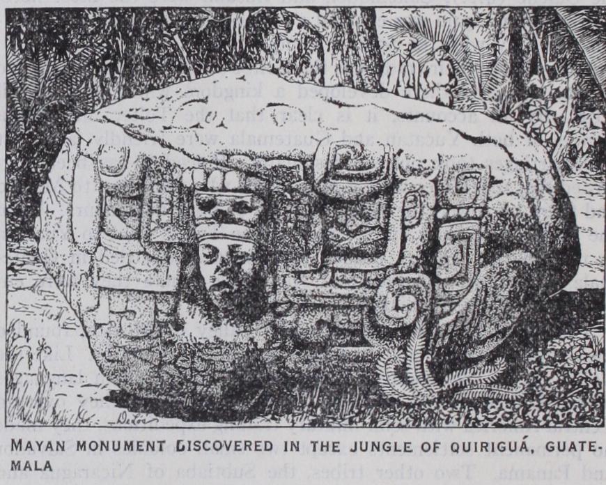
By the beginning of the Christian era two large linguistic groups, Maya and Chorotega, had assumed a definitely historic pattern. Owing to their use of writing and the calendar, definite dates can be applied to their archaeological remains thencefor ward. The Chorotega then lived in western Honduras and pos sibly parts of Guatemala. From this region they were displaced by the Maya, who forced them to move to the north and south. At the time of the Spanish conquest they had settled in southern Mexico and also on the south coasts of Costa Rica, Nicaragua and Honduras. The first great Maya cities arose on the plains of northern Guatemala, to-day an almost uninhabited jungle. Here they erected a host of well-built edifices of stone and concrete. About the beginning of the 6th century A.D. construction ceased, and it has generally been assumed that the Maya immediately abandoned these cities. Recent archaeological studies, however, indicate that they continued to occupy some at least of the older towns. At any rate, it is known, from ancient writings, that the Maya had discovered and partly colonized Yucatan as early as the 4th century. They now proceeded to populate it and also the highlands of southern Mexico and Guatemala. By the r i th cen tury both in Yucatan and Guatemala the Maya had established a series of powerful principalities and again were housed in well built cities of stone. In Yucatan there arose a league of three princely houses, the Itza, Xiu, and Cocom, who dominated the peninsula in unity for 200 years. In A.D. 1201, a civil war broke out, the Itza capital was sacked with the aid of Toltec mercen aries, and the Itza were forced to withdraw to the jungles of Gua temala, where they maintained their ancient civilization against all attacks until the end of the r 7th century. In Yucatan the Cocom family became the overlords of the peninsula, but they were overthrown in turn by a coalition of petty princes organized by the Xiu in 1458. When the Spaniards reached Yucatan it was badly disorganized politically as it had been ravaged for over 300 years by intermittent warfare.
In Guatemala by the r 2th century there had also arisen a series of well-organized kingdoms and principalities, of which those of the Quiche (q.v.), Cakchiquel, and Zutuhil were the most note worthy. Here again was enacted a series of bitter wars which ter minated only with the Spanish conquest.
According to their traditions the Toltec settled in central Mexico in A.D. 752, and there developed a kingdom which lasted until 107o. By all accounts, it is clear that the Toltec and Maya princes of both Yucatan and Guatemala were friendly, and that intermarriages took place occasionally. Indeed it has been sug gested that the Toltec were a Maya tribe who wandered to Mexico and there borrowed the Nahua tongue of their neighbours. Upon the downfall of their empire part of the Toltec went to Yucatan as mercenaries. Others pushed southward and settled in Guate mala, Honduras, Salvador and Nicaragua, where they were en countered by the Spaniards.
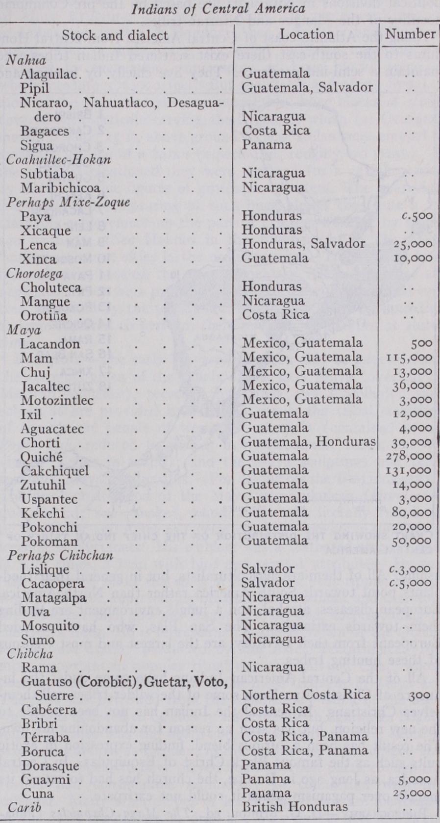
The Aztec, the last corners in the Valley of Mexico, founded their capital in 1325 and rapidly rose in military power. Like the Toltec they spoke Nahuatl, a tongue related to Indian languages of the United States, such as the Ute. Although they overran Central America with semi-military trading expeditions, they made no permanent settlements except two small colonies in Salvador and Panama. Two other tribes, the Subtiaba of Nicaragua and the Tlappanec of Guerrero, both small and obscure peoples, show linguistic connection with the United States. Their tongues have recently been connected with the Coahuiltecan languages of northern Mexico and Texas as well as with the Hokan of Cali fornia. Other small tribes exist in Central America but their linguistic relationship remains doubtful. These include the Xicaque, Lenca and Paya of Honduras and the Xinca of Guate mala. It has been suggested that they are related to each other and to the Mixe-Zoque tongues of southern Mexico.
Finally, on the north coast of Honduras and adjacent portions of British Honduras there live Carib Indians. They came origi nally from St. Vincent where they caused the English much trouble. In 1796 they were deported at a cost of nearly $5,000,000, Many of them show a strong infusion of negro blood.
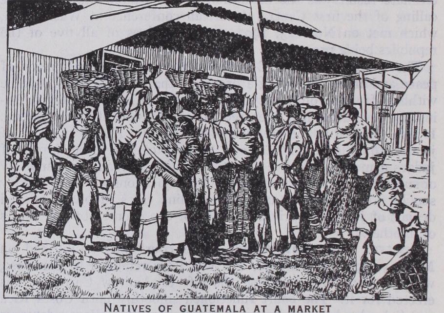
The conditions under which individual Indian tribes live to-day in Central America depends on their inherited culture, their environment, and their culture-contacts with Europeans. In Guatemala throughout the highlands the Indian has been forced to support the European population through a system of peonage little better than slavery. However, he has maintained his racial purity, his language, his distinctive and beautiful costumes, and beneath a veneer of Christianity, much of his ancient religion. In this region, the European domination has meant for the Indian the introduction of new food plants such as coffee, the substitution of taskmasters of his own race by foreigners, and the suppression of certain liberties such as intertribal warfare and religious ritual. Their lot is not enviable, but probably they are as well off mate rially, excepting the ancient nobility, as before the Conquest. In Honduras, Salvador (except the west) and Nicaragua, most of the Indian population has fused with European blood to form the ladino class, which makes up the bulk of the population. Aspiring to a European scale of living, these people often retain many traits of their Indian ancestors, and through poverty are forced to exist in the same manner as the Indians themselves. There is little social discrimination against the ladino, so, as he usually owns little or no property, he often resorts to violent political action as a short cut to wealth. Indeed it is said that the present political divisions in Nicaragua are based on the pre-Columbian hostility of the Mangue and Nicarao tribes.
Along the Atlantic coast of Central America from central Hon duras to the south-east there exist scattered Indian tribes who maintain a semi-independence. They live chiefly by hunting and fishing. All of them are agriculturalists, but in general their f ood plants point towards South America rather than North America. European diseases, alcohol, and a jungle environment are leading them towards extinction. The San Bias, who have excluded Europeans from their territory, are the largest and most vigorous of these hunting tribes.

All of the Central American Indians have come under the in fluence of Christianity. Even some of the wilder tribes call them selves Christians. In general the Indian has not been hostile to the new religion, but has seen no reason for abandoning his own. The result has been a curious blend, finding expression in exotic cults such as the famous Black Christ of Esquipulas. In Central America, as long ago in Europe, the church has had to extend its mantle over paganism which it could not extirpate.
BIBLIOGRAPHY.-D. G. Brinton, ed., The Maya Chronicles (PhilaBibliography.-D. G. Brinton, ed., The Maya Chronicles (Phila- delphia, 1882) ; also Annals of the Cakchiquels (Philadelphia, 1885) ; Brasseur de Bourbourg, ed., Popol Vuh (1861) ; E. G. Squier, Notes on Central America (1855) ; Walter Lehmann, Zentral-Amerika (192o) ; Cyrus Thomas and J. R. Swanton, "Indian Languages of Mexico and Central America," Bul. 1, 44. Bureau of American Eth nology (191I) ; W. M. Gabb, On the Indian tribes and languages of Costa Rica, Proc. Am. Philos. Soc. vol. xiv. (Philadelphia, 1875) ; Karl Sapper, Mittelamerikanische Reisen aus Studien aus den Jahren 1888 bis 1900 (Braunschweig, 1902), "Der gegenwartige Stand der ethno graphischen Kenntnis von Mittelamerika," in Archiv. fur Anthropolo gie, N.F. Bd. iii. (Braunschweig, 1904). (S. K. L.) The archaeology of Mexico and Central America cannot be discussed in terms of modern geography. The southern half of Mexico, with Guatemala, British Honduras, the north of the republic of Honduras (at least) and Salvador, constitute an archaeological complex which can only be examined as a whole. Further south, the ancient culture of Nicaragua is still very obscure, although it was evidently subjected to influences from the north. These influences extended into certain regions of Costa Rica, and even of Panama, although, in the two last-named Republics, they were clearly of late introduction, and the indige nous culture displays increasing affinities with that of the Southern Continent. The region as a whole is characterised by great lin guistic diversity, but certain main groups may be distinguished which appear to coincide fairly accurately with the archaeological areas. Details may be obtained from the linguistic surveys published by Thomas, Swanton and Lehmann.
The Antilles, ethnologically and culturally belong to South America, and their archaeology is treated in connection with that of the Southern Continent.
The Maya occupation of Yucatan is generally known as the "New Empire," and is distinguished by a modification of the dat ing system, and certain architectural and artistic peculiarities, best expressed in the important settlements of Chichen Itza and Uxmal. A further development occurred later, owing to Toltec influences emanating from the Valley of Mexico (see below). For this period there exist certain semi-historical documents, the chronicles of the Tutul-Xiu tribe (known as the Books of Chillan Balam), which were reduced to writing in post-conquest times and the invaluable account of Bishop Landa (1 566) (see Bibli ography). Though the main body of the early Maya migrated north, it is clear that a branch travelled west, because monuments, bearing dates later than any of those within the early Maya area, have been discovered at Sacchana in the direction of Oaxaca. In fact the Maya calendar, and much of Maya culture, appears to have been adopted by the Zapotec tribes of Oaxaca, and to have spread thence to the Valley of Mexico, though in attenuated form. Here it was developed by the Toltec, the first wave of a stream of immigrants from the north (all speaking dialects of a common language, known as Nahuatl) of which the final wave was repre sented by the Aztec. The ultimate rise to power of the Aztec resulted in the emigration of large bodies of Toltec from Mexico, and the spread of Toltec influence among the Totonac peoples of Vera Cruz, and the later Maya of Yucatan. An interesting prob lem is provided by the Huaxtec people, inhabiting the Panuco Valley, north of the Totonac, and separated by them from the main body of Maya to whom they belong linguistically. Stone sculpture has been found in this area, but no trace of a script. Their pottery bears a close resemblance to the pre-Toltec remains of the Mexican Valley, and to certain, apparently, very early pot tery discovered in the Maya Area. They represent apparently, a very early branch of the Maya stock, isolated by the intrusion of immigrant tribes before the great development of Maya culture. Further results of the successive incursions of Nahuatl-speaking tribes from the north are indicated in subsequent paragraphs.
Mexican immigration into Yucatan heralded the disruption of the later Maya Empire. For two centuries the country was con trolled by a "triple alliance" between the settlements of Chichen Itza, Uxmal and Mayapan. Dissension arose and the rulers of Mayapan employed Toltec mercenaries to coerce their allies. The Toltec received Chichen Itza as the reward of their aid, and erected there some of the most imposing buildings in their own tra ditional style. Subsequent history is concerned with the inter necine feuds of the various clans, and internal strife, complicated by pestilence, had seriously reduced the level of Maya culture by the time that the arrival of the Spaniards extinguished it for ever.
The Early Maya were masters in the art not only of stone cutting and polishing, but of stone-flaking. The implements of chert, chalcedony and obsidian, fashioned both by primary and secondary flaking, can hardly be surpassed throughout the world. The art of pottery-making was highly developed under the Early Maya regime. The wheel was unknown, but the various processes of modelling, coiling and even moulding were prac tised from early times. Ornamentation was provided by means of painting in slip, by incision in the damp clay, by engraving after sun-drying or firing, or by means of stamps. Forms were ex tremely varied. Tripod bowls and vertical-sided beakers are especially characteristic, but vases in animal form were not un common. Apart from the coarse domestic utensils, Maya pottery shows good quality in paste and firing, and certain of the poly chrome varieties are excellent examples of slip-painting. At present, investigation has not proceeded far enough to enable Maya pottery to be classified, save very roughly, in any sort of chronological sequence. An intensive study of Maya ceramics from this point of view would undoubtedly produce results of the highest importance. There is strong indication that certain districts within the Maya area were centres of pottery manu facture, whence the products of the local industry were distrib uted far and wide by exchange and trade. Further investigation in this direction provides a very promising field of inquiry. Pottery figurines, often in the form of ocarinas, are common, and it is recorded that idols on a comparatively large scale were made by the late Maya in this material. (See Joyce in Bibliog raphy.) No specimens of textile art belonging to the Maya Period have survived the climate. But the monuments provide ample evi dence that the weaver's art had reached a high degree of pro ficiency. Many of the figures are shown with garments orna mented with inwoven patterns and furnished with embroidered borders and tasselled fringes. All of these exhibit a perfection of technique which, like the stone-carving, implies a long period of development.
It is a little uncertain whether the Maya of the early period were acquainted with metal in any form. The late Maya cer tainly knew gold, worked it both by hammering and by the cire-perdue process, and also used copper to a limited extent, principally for ornaments. But only a single object in gold has been discovered at an early Maya site and this may well be rela tively late in date.