
COLORADO, known as the "Centennial State" because of its entrance into the Union in 1876, oo years after the Declara tion of Independence, is a State of the United States of America, situated between 37° and 41° N. lat. and io2° and 1o9° W. longi tude. The State is bounded on the north by Wyoming and Nebraska, on the east by Nebraska and Kansas, on the south by Oklahoma and New Mexico and on the west by Utah. It is the seventh largest State in the Union, having an area of 103,948 sq.m., of which 290 are water surface.
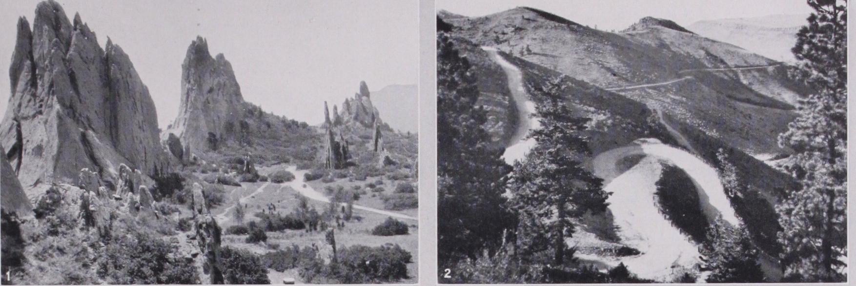
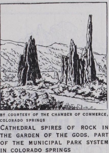
On the western edge of these plains lies an abrupt, massive and strangely uniform chain of mountains, known in the neighbour hood of Colorado Springs as the Rampart range, and in the extreme north as the Front range, and often denominated as a whole by the latter name. The upturning of the rocks of the Great Plains at the foot of the Front range develops an interest ing topography, the harder layers weathering into grotesquely curious forms, as seen in the famous Garden of the Gods at the foot of Pikes peak. Behind this barrier the whole country is elevated about 2,000 ft. above the level of the plains region. In its lowest portions just behind the front ranges are the natural "parks"—great plateaux enclosed by superb ranges. To the west of these and between them, and covering the remainder of the State east of the plateau region, is an entanglement of mountains, tier above tier, running from north to south, buttressed laterally with splendid spurs, cut by river valleys and divided by mesas and plateaux. These various chains are known by a multitude of local names. Among the finest of the chains are the Rampart, Sangre de Cristo, San Juan, Sawatch (Saguache) and Elk ranges. The first, like the other ranges abutting from north to south upon the region of the prairie, rises abruptly from the plain and has a fine, bold outline. It contains a number of fine summits dominated by Pikes peak (14,i o ft.). Much more beautiful as a whole is the Sangre de Cristo range. At its southern end are Blanca peak 04.363 ft.) and Old Baldy (14,125 ft.), both in Costilla county. The mountains of the San Juan ranges of the south-west are particularly abrupt and jagged. Most magnificent of all the mountains of Colorado, however, are the Sawatch and adjoining ranges in the centre of the State. The former (the name is used a little loosely) consists of almost a solid mass of granite, has an average elevation of probably 13,000 ft., presents a broad and massive outline and has a mean breadth of 15 to 20 miles. Mt. Ouray (13,955 ft.), in Chaffee county, may be taken as the southern end, and the splendid Mount of the Holy Cross (13,978 ft.), in Eagle county—so named from the figure of its snow-filled ravines—as the northern. Between the two lie numer ous high peaks including Mt. Elbert (14,42o ft.), the highest peak in the State. The Elk range is geologically interesting for the almost unexampled displacement of the strata of which it is composed and the apparent confusion which has thence arisen. The most remarkable of its separate summits, which rise superbly in a crescent about Aspen, is North Italian peak (13,225 ft.), displaying the red, white and green of Italy's national colours. A few miles to the north and north-east of the Mount of the Holy Cross are Torrey peak (14,336 ft.) and Grays peak (14,341 ft.), in Summit county; Mt. Evans (14,259 ft.), in Clear Creek county; and Rosalie' peak 03)574 ft.), in Park county; a little farther north, in Gilpin, Grand and Clear Creek counties, James peak (13,259 ft.), and, in Boulder county, Longs peak (14,255 feet). Altogether there are at least 600 summits exceeding 12,000 ft. in altitude, 30o above 13,000 and 46 above 14,000.

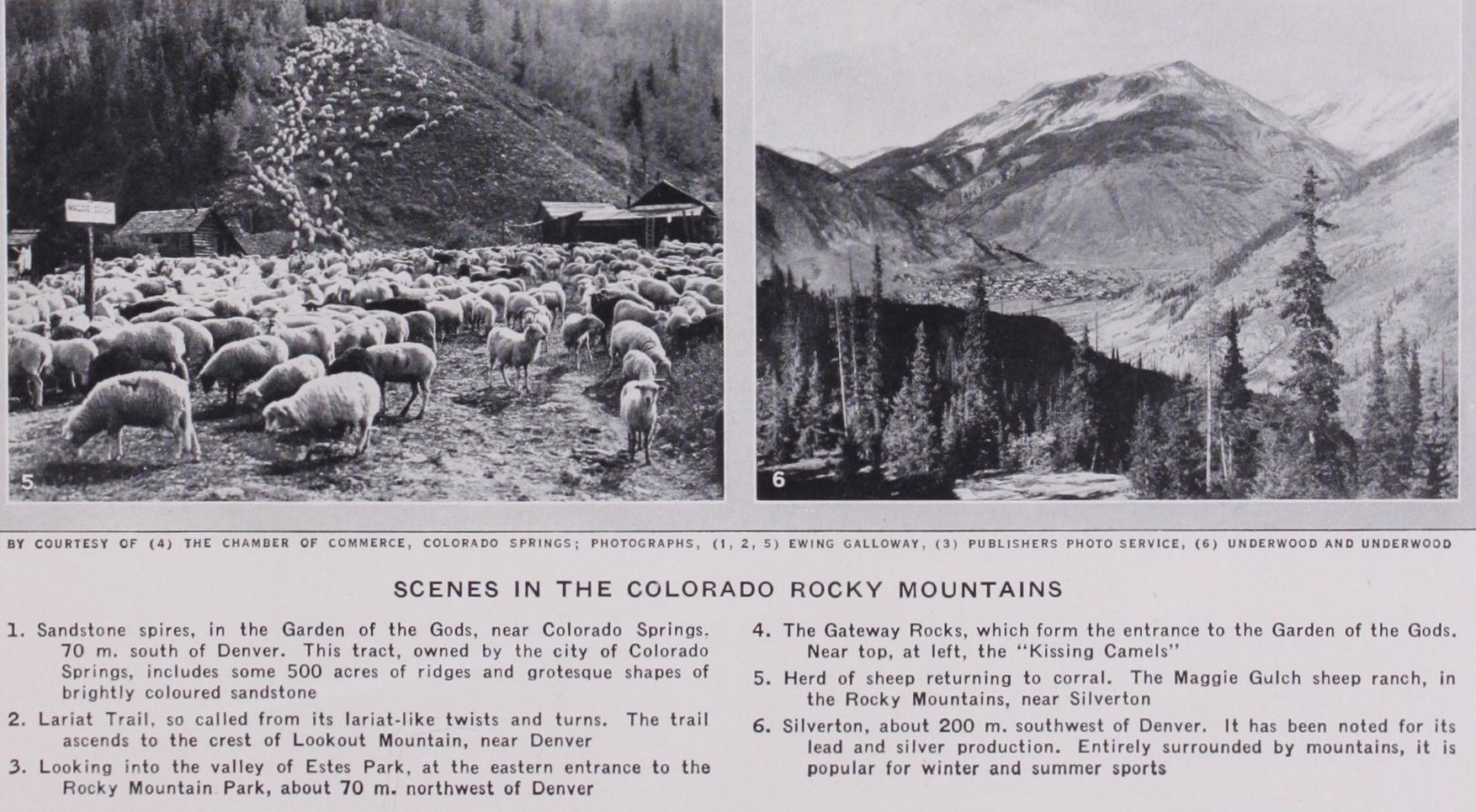
Cirques, valley troughs, numberless beautiful cascades, sharp ened alpine peaks and ridges, glacial lakes and valley moraines offer everywhere abundant evidence of glacial action, which has modified profoundly practically all the ranges. The Park range, east of Leadville, and the Sawatch range are particularly fine examples. Much of the grandest scenery is due to glaciation. Among the most remarkable orographical features of the State are the great mountain "parks"— North, Estes, Middle, South and San Luis—extending from the northern to the southern border of the State, .and lying (with the exception of Middle park) just east of the continental divide. These "parks" are great plateaux, not all of them level, lying be low the barriers of surrounding mountain chains. North park, the highest of all, is a lovely country of meadow and forest. Middle park is not level, but is traversed thickly by low ranges like the Alleghenies ; in the bordering mountain rim are several of the grandest mountain peaks and some of the most magnificent scenery of the State. Estes park is small, only 20 m. long and never more than 2 M. broad ; it is in fact the valley of Thompson creek. By many it is accounted among the loveliest of Colorado valleys. Seven ranges lie between it and the plains. South park is similarly quiet and charming in character. Much greater than these is San Luis park. The surface is nearly as flat as a lake, and it was probably at one time the bed of an inland sea. In the centre there is a long narrow lake fed by many streams. It has no visible outlet, but is fresh. The San Luis park, which runs into New Mexico, is traversed by the Rio Grande del Norte and more than a dozen of its mountain tributaries. These parks are frequented by great quantities of large game, and--especially the North and Middle— are famous hunting-grounds. They are fertile, too, and their corn bined area is something like r 3,00o sq. miles.
The drainage system of the State is complicated. Eleven topo graphical and climatic divisions are recognized by the United States Weather Bureau within its borders, including the several parks, the continental divide and various river valleys. Of the riv ers, the North Platte has its sources in North park; the Colorado (the Grand branch), in Middle park; the South Platte, in South park; the Arkansas, in Lake county; and the Rio Grande in San Luis park. Four of these flow east and south-east to the Missouri, the Mississippi and the gulf ; but the waters of the Colorado sys tem flow to the south-west into the Gulf of California. Among the other streams, almost countless in number among the mountains, the systems of the Dolores, White and Yampa, all in the west, are of primary importance. The scenery on the head-waters of the White and Bear, the upper tributaries of the Gunnison and on many of the minor rivers of the south-west, is wonderfully beauti ful. The South Platte falls 4,830 ft. in the 139 m. above Denver; the Grand, 3,60o ft. in the 224 m. between the mouth of the Gun nison and the Forks; the Gunnison, 6,477 ft. in the 200 M. to its mouth (except for 16 m., never with a gradient of less than ro ft.) ; the Arkansas, 7,00o ft. in its 338 m. west of the Kansas line. Of the smaller streams the Uncompahgre falls 2, 70o ft. in 134 m., the Las Animas 7, r oo ft. in 113 m., the Los Pinos 4,92o ft. in 75 m., the Roaring Fork 5,923 ft. in 64 m., the Mancos 5,00o ft. in 62 m., the La Plata 3,1o3 ft. in 43 m., the Eagle 4,293 ft. in 62 m., the San Juan 3,785 ft. in 303 m., the Lake Fork of the Gunnison 6,047 ft. in 59 miles. The canyons formed in the moun tains by these streams are among the glories of Colorado and of America. The grandest are the Toltec gorge near the southern boundary line, traversed by the railway i , soo ft. above the bottom; the Red gorge and Rouge canyon of the Upper Grand, and a splendid gorge 16 m. long below the mouth of the Eagle, with walls 2,000-2, 50o ft. in height ; the Grand canyon of the Arkansas (8 m.) above Canyon city, with granite walls towering 2,60o ft. above the boiling river at the Royal gorge ; and the superb Black canyon (15 m.) of the Gunnison and the Cimarron. But there are scores of others which, though less grand, are hardly less beautiful. The exquisite colour contrasts of the Cheyenne canyons near Colorado Springs, Boulder canyon near the city of the same name, Red Cliff and Eagle River canyons near Red Cliff, Clear Creek canyon near Denver—with walls at places i,000 ft. in height—the Granite canyon (r r m.) of the South Platte west of Florissant, and the fine gorge of the Rio de las Animas (1,5oo ft.), would be considered wonderful in any State less rich in still more marvellous scenery. Among the peculiar features of the mountain landscapes are the mines. In districts like that of Cripple Creek their enormous ore "dumps" dot the mountain flanks like scores of vast ant—hills; and in Eagle River canyon their mouths, like dormer windows into the granite mountain roof, may be seen 2,000 ft. above the railway. More than a dozen mountain passes lie above r o,000 feet. Argentine pass (13,132 ft.), near Grays peak, is one of the highest wagon roads of the world; just east of Silverton is Rio Grande pass, about 12,400 ft. above sea level, and in the Elk mountains between Gunnison and Pitkin counties is Pearl pass (12,715 feet) . Many passes are traversed by the railways, especially the splendid scenic route of the Denver and Rio Grande Western, with a water-level route through the Royal gorge of the Arkansas river. Among the higher passes are Hoosier pass (10,313 ft.) in the Park range; Hayden Divide (ro,78o) and La Veta pass (9,378), both of these across the Sangre de Cristo range ; the crossing of the San Miguel chain at Lizard Head pass (ro,25o) near Rico; of the Uncompahgre at Dallas Divide (8,977) near Ouray; of the Elk and Sawatch ranges at Fremont (r1,32o), Tennessee (10,276) and Breckenridge 01,503) passes, and the Busk tunnel, all near Leadville; and Marshall pass (ro,95o) above Salida.
The climate of Colorado is exceptional for regularity and salubrity. The mean annual temperature for the State is about 46° F. Owing to the complex orography of the State, few climatic generalizations can be made. It may be said, however, that the south-east is the warmest portion, lying as it does outside the mountains; that the north-central region is usually coldest; that the normal yearly rainfall for the entire State is about 15.5 in., with great local variations (rarely above 27 in.). Winds are constant and rather high (5 to r o m.), and for many persons are the most trying feature of the climate. Very intense cold pre vails in winter in the mountains, and intense heat (r ro° F or more in the shade) is often experienced in summer, temperatures above 9o° being very common. Nevertheless, the climate of Colorado is not to be judged severe, and that of the plains region is in many ways ideal. In the lowlands the snow is always slight and it disappears almost immediately, even in the very foothills of the mountains, as at Denver or Colorado Springs. However hot the summer day, its night is always cool and dewless. Between July and October there is little rain, day after day bringing a bright and cloudless sky. Humidity is moderate (annual averages for Grand Junction, Pueblo, Denver and Cheyenne, Wyo., for 6 A.M., about 5o to 66; for 6 P.M., 33 to 50). Sunshine is almost continuous; for the whole State the average of perfectly "clear" days is normally above 5o%. Colorado, because of its lowness of humidity and clarity of atmosphere, has many famous arid health resorts.
Large game is still found in limited numbers west of the con tinental divide. The great parks are a favourite range and shelter. Deer and elk frequent the mountains of the north-west, in Routt and Rio Blanco counties, adjoining the reservations of the Un compahgre and Uintah Ute Indians. The bison have been ex terminated. Considerable bands of antelope live in the parks, and even descend to the eastern plains, and the mule-deer, the most common of large game, is found through the mountains of the west. Grizzly or silver-tip, brown and black bears are found in the same region. Rarest of all is the magnificent mountain sheep. Game is protected zeal ously, if not successfully, by the State. Fish are not naturally very abundant, but the mountain brooks are the finest home for trout, and these, as well as bass, catfish and some other varieties, have been used to stock the streams.
Soil.—The soils of the low lands are prevailingly sandy loams, with a covering of rich mould. The lands available for agriculture are the lowlands and the mountain parks and valleys.
Cultivation is not intensive.
Speaking generally, irrigation is essential to successful cultivation, and where it is practicable the soil proves richly productive. Irri gation ditches having been exempted from taxation in 1872, exten sive systems of canals were soon developed, especially after 1880. The Constitution of Colorado declares the waters of its streams to be the property of the State, and a great body of irrigation law and practice has grown up about this provision. The riparian doctrine does not obtain in Colorado. In no other part of the semi-arid region of the country are the irrigation problems so diverse and difficult. The average annual cost of water per acre, in 1919, was estimated at about 87 cents. There are irrigated lands in every county. As a result of irrigation the Platte is often dry in eastern Colorado in the summer, and the Arkansas shrinks so below Pueblo that little water reaches Kansas. The water is almost wholly taken from the rivers, but underflow is also uti lized, especially in San Luis park. The South Platte is much the most important irrigating stream. The exhaustion, or alleged ex haustion, by irrigation in Colorado of the waters of the Rio Grande, has raised international questions of much interest be tween Mexico and the United States, which were settled in 1907 by a convention pledging the United States to deliver 6o,000 ac.f t. of water annually in the bed of the Rio Grande at the Acequia Madre, just above Juarez; in case of drought this supply being diminished propor tionately to the diminution in the United States. One of the greatest undertakings of the na tional reclamation service is the construction of 77 m. of canal and of a 6 m. tunnel, beneath a mountain, between the canyon of the Gunnison and the valley of the Uncompahgre, designed to make productive some 140,000 ac. in the latter valley. Stock-raising has always been important. The parks and mountain valleys are largely given over to ranges. The native grasses are especially adapted for f odder. The grama, buffalo, and bunch varieties cure on the stem and furnish through out the winter an excellent range food. These native grasses, even the thin bunch varieties of dry hills, are surprisingly nutritious, comparing very favourably with cultivated grasses. Large areas temporarily devoted to cultivation with poor success, and later allowed to revert to ranges, have become prosperous and even noted as stock country. This is true of the sand-hill region of eastern Colorado. The grass flora of the lowlands is not so rich in variety nor so abundant in quality as that of high altitudes.
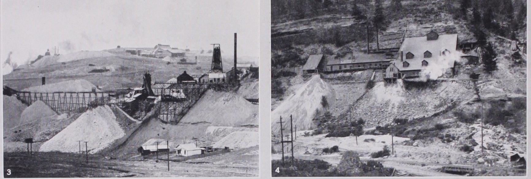
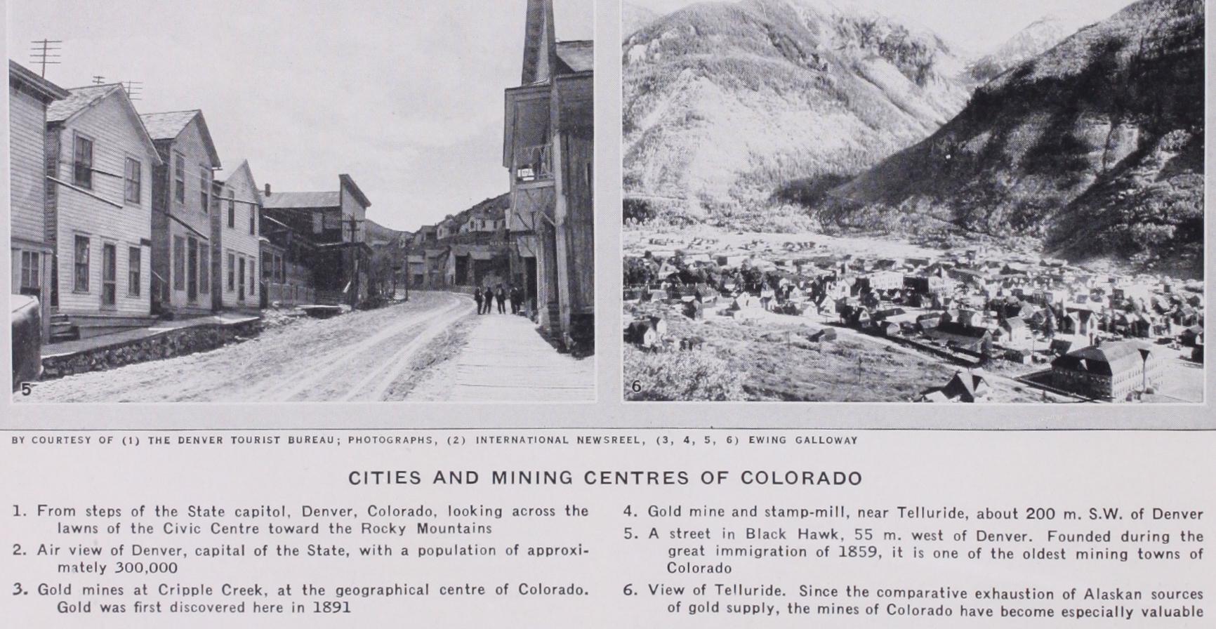
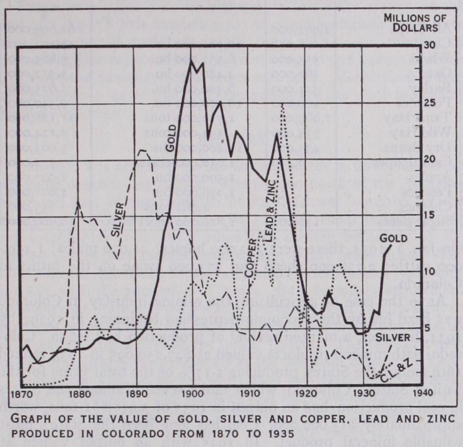
Minerals.--Colorado is pre-eminently a mineral region, and to this fact it owes its colonization. It possesses unlimited supplies, as yet not greatly exploited, of fine building stones, some oil and asphalt and related bituminous products, a few precious and semi-precious stones (especially tourmalines, beryls and aqua marines found near Canyon, near the Royal gorge of the Arkansas river), rare opalized and jasperized wood (in the eastern part of El Paso county), considerable wealth of lead and copper, enormous fields of bituminous coal and great wealth of the precious metals. In the exploitation of the last there have been three periods : That before the discovery of the lead-carbonate silver ores of Leadville in 1879, in which period gold-mining was predominant ; the succeeding years until 1894, in which silver mining was predominant ; and the period since 1894, in which gold has attained the primacy. The two metals are found in more than 5o counties, San Miguel, Gilpin, Pitkin, Clear Creek, Lake, San Juan and Teller being the leading producers. The Cripple Creek field in the last-named county was one of the most wonder ful mining districts of America. Leadville, in Lake county, was another. The district about Silverton (product 187o–I900 about $35,000,000, principally silver and lead, and mostly after 1881) also had a remarkable development ; and Creede, in the years of its brief prosperity, was a phenomenal silver-field.
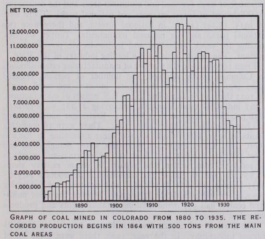
The stratified rocks of the Great Plains, the parks and the plateaux contain enormous quantities of coal. The coal-bearing rocks are confined to the Upper Cretaceous, and almost wholly to the Laramie formation. The main areas are on the two flanks of the Rockies, with two smaller fields in the parks. The east group includes the fields of Canyon city (whose product is the ideal domestic coal of the western States), Raton and the South Platte ; the park group includes the Cones field and the Middle park; the west group includes the Yampa, La Plata and Grand River fields. The total includes every variety from typical lignite to typical anthracite. The aggregate area of beds is estimated by the United States Geological Survey at 18,1oo sq.m. (seventh in rank of the States of the Union) ; and the accessible coal, on other authority, at 33,897,800,00o tons. The industry began in 1864, in which year 5oo tons were produced. The product first exceeded one million tons in 1882, two in 1888, three in 1890, four in 1893, five in 1900.
Mineral springs are numerous and occur in various parts of the State. The most important are at Buena Vista, Ouray, Wagon Wheel gap, Poncha or Poncha springs (9e--185° F), Canyon city, Manitou, Idaho springs and Glenwood springs (12e-14o° F, highly mineralized) . The last three places, all beautifully situated —the first at the base of Pike's peak, the second in the Clear creek canyon, and the third at the junction of the Roaring Fork with the Grand river—have an especially high repute.
Women have served in the legis lature and in many minor offices.
The governor may veto any sep arate item in an appropriation bill. The State treasurer and aud itor may not hold office for two consecutive terms. Popular initia tive and referendum were intro duced in 1910, recall of officials in 1912. County government is of the commissioner type.
The population of the State in 193o was 1,035,791 (United States census). The first census of Colorado, taken in 186o, showed a population of 34,277. The population at other census periods was as follows: In 1870, 39,864; in 188o, 194,3 2 7 ; in 1890, 413,249; in 1900, 539,700; in 1910, 799,024; in 1920, The decade 1920-3o showed an increase of 96,162, or 10.2 %, as compared with 17.6% in the preceding census period. In 1930, 91.8% of the population were native-born, 98.4% being whites. Negroes and Indians numbered 13,223, and there were Chinese and 3,213 Japanese. The density of population increased from 9.1 persons per sq.m. in 1920 to in 1930.
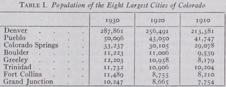
The decay of mining towns, notably Leadville, Cripple Creek and Creede altered the balance between urban and rural popula tion. In 193o the urban population was 5o.2 % of the whole, the rural 49.8%. The table shows the comparative population figures for the eight largest cities. Roman Catholics are in the lead among church adherents; of the Protestant denominations, Metho dists, Presbyterians and Baptists are most numerous. The South Ute Indian reservation in the south of the State, 619 sq.m. in area, is the home of the Moache, Capote and Wininuche Utes, of Shoshonean stock.
Of charitable and reformatory institutions, a soldiers' and sailors' home is maintained at Monte Vista, an insane hospital at Pueblo, a home for dependent and neglected children at Denver, homes for mental defectives at Ridge and Grand Junction, an industrial school for girls near Morrison, and for boys at Golden, a reformatory at Buena Vista and a penitentiary at Canyon City. Denver was one of the earlier cities in the country to institute special courts for juvenile offenders, a reform that is widening in influence and promise. The parole system is in force in the State reformatory, and in the industrial school at Golden (for youthful offenders) no locks, bars or cells are used, the theory being to treat the inmates as "students." The State has a parole law and an indeterminate-sentence law for convicts.
As in the case of agriculture, the mining industry in Colorado was hard hit by the economic depression beginning in 1929; by 1934, however, a marked revival of production had set in. Colo rado, with mineral products valued at $27,259,095 in 1933 ranked r6th among the States, producing r•I7% of the total value for the United States. Colorado, which ranks seventh among the States in coal production, had an output in 1935 of 5,948,681 tons, worth approximately $15,000,000. Coal has long been the State's most valuable mineral product. In 1935 with an output valued at $12,224,828, Colorado ranked fourth among the States in gold production. It was fifth for silver, with output worth $2,189,651 and seventh for lead and for zinc. The production of lead and of zinc in 1935 had dropped to $453,800 and $105,732, respectively. Petroleum production dropped from 2,750,060 bbl. in 1928 to 908,504 in 1933; bY 1935 it had picked up to 1,523,450 bbl. val ued at $1,410,209. Brick and other clay products, in 1933 had a value of $870,488.
A marked influence on Colorado's economic life is found in the existence of large forested and mountain areas and the consequent establishment of forest reserves and national parks. There were in 1935, 13,547,537 ac. in national forests, and there were two national parks and six national monuments. Timber supplies, grazing for stock, irrigation and hydro-electric power are im portant. The tourist business is a leading industry of the State.
From 1900 to 1920 the number of manufacturing establishments in Colorado nearly doubled, the number of persons engaged more than doubled, and the capital invested increased 225%. In 1933 there were, according to the U.S. census of manufactures, 1,067 industrial establishments, employing 21,287 wage-earners, with products valued at $135,868,377. Beet-sugar manufacturing has been the chief industry since 1914. There were 16 operating plants in 1935, which manufactured sugar amounting tO 290,000 short tons. Other important industries were: Slaughtering and meat packing $16,021,345; flour arid other grain-mill products $4,496,657; construction and repairs in steam railway shops $5,890,209; butter, cheese, and condensed milk products $5,570, 963; bakery products $7,187,762; and printing and publishing newspapers and periodicals $7,504,046. Denver, the chief indus trial centre, had 572 manufacturing establishments and products valued at $64,031,329.
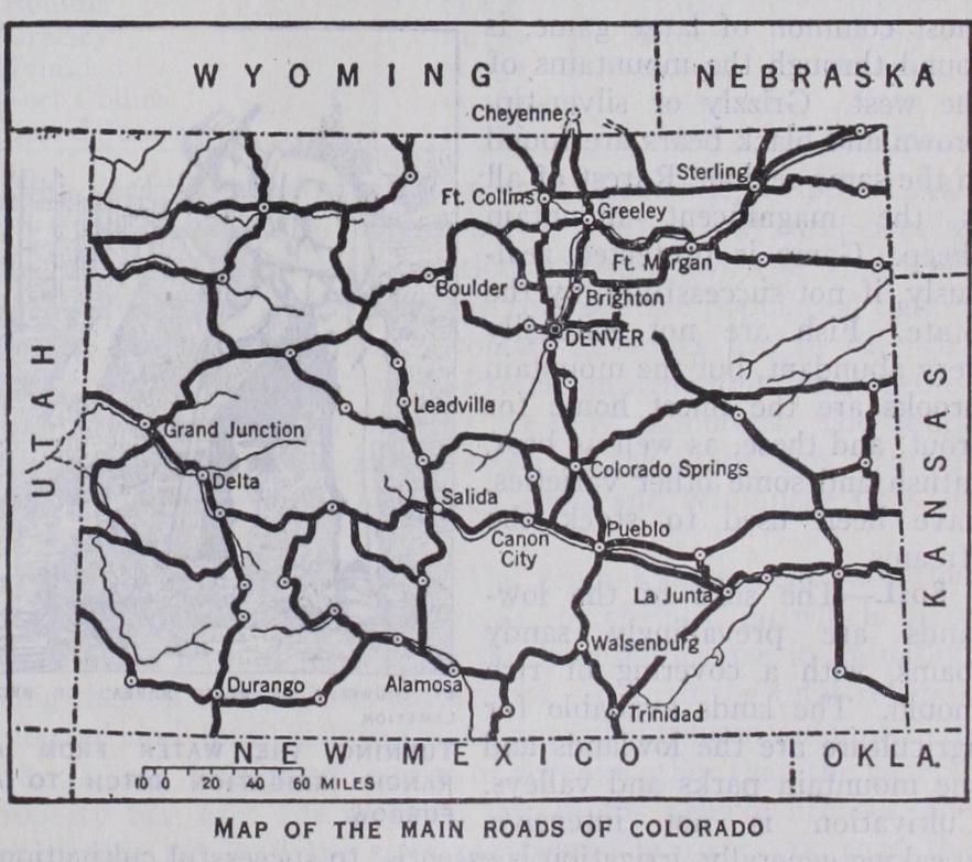
The State is well supplied with railway mileage in spite of its rugged topography. In the year, 1936, there were 4,981 m. of main line railways in operation—a decline from the 5,724 m. in operation in 1915. The Denver Pacific, built from Cheyenne, Wyo., reached Denver in June 187o, and the Kansas Pacific, from Kansas City, in August of the same year. Then followed the building of the Denver and Rio Grande (1871), to which the earlier development of the State is largely due. The Santa Fe (1873), Burlington (1882), Missouri Pacific (i887) and Rock Island (1888) systems reached Pueblo, Denver and Colorado Springs successively from the east. The Colorado and Southern, a consolidation of roads connecting Colorado with the south, and the Denver and Salt Lake have also become important. The electric railway systems, operated by eight companies, had in 1932 a total of 308 m. of track.
There were 9,421.7 m. of highway in the State system at the end of 1934. Of this amount 5,333 m. were surfaced; there were also 8,466 m. of surfaced county roads. The total number of motor vehicles registered in the year 1935 was 285,479, of which 256,148 were passenger cars, buses and taxis. Motor licence fees and a gasolene tax of five cents per gallon are the chief sources of highway revenue.
Colorado was acquired by the United States in three successive waves of westward expansion. The portion north of the Arkansas river and east of the meridian of its head was acquired by the Louisiana Purchase (q.v.) in 1803, but its exact boundary was not established until 1819, when the western boundary of the United States was incorporated in the treaty with Spain. The boundary of the United States was extended farther westward in 1845, with the admission of Texas. By a boundary adjustment between that State and the Federal Government in 185o, a strip of territory between the Rio Grande river and the present boundaries of Texas became a part of the public domain. The territory west of the Rio Grande was included in the Mexican cession of 1848.
Before the coming of the white men two types of Indians in habited the country. The southern and south-western parts of the State were occupied by the cliff-dwellers, a sedentary, agricultural people. On the plains and to the northward dwelt the Utes and other nomadic, hunting tribes. Only a few of the pueblos and cave dwellings remain to commemorate the Indian culture of the south-west.
Colorado was a great cattle country until about 189o, when the free range began to pass away because of fencing for agricultural enterprises. The cattlemen had to adjust themselves to the new situation by providing winter forage, and this led to the culti vation of alfalfa and other hays. Later, with the introduction of the sugar-beet industry, Colorado regained some of its former importance as a meat-producing State. Lambs and cattle are fattened on the hay crops, and swine and cattle consume the by products of the sugar-beet industry.
The legislature in 1919 passed an act providing for a budget system in making appropriations and creating a State budget and efficiency commissioner. The first budget prepared under this act was presented to the legislature in 1921. In 1920 the voters adopted an initiated constitutional amendment raising the limit on State tax levy from $4,000,00o to $5,000,000, the additional $1,000,00o to provide buildings for educational institutions. In 1921 a proposed amendment to extend the tenure of office of State and county officers was defeated. Proposals for a conven tion to revise the State constitution were rejected in 192I and 193o. In 1921 inheritance tax laws were strengthened by raising the rates thereof. Persistent advocacy by the governor secured the passage of laws for the re-establishment of a national guard and for a Department of Safety, with a body of rangers as a State police force; the latter was disbanded in 1923. The legislature in 1922 voted a $6,700,00o bond issue to finance the Moffat tun nel, and before it was completed in 1934 a total issue of $18,000,00o had been authorized. A loan of $3,850,00o from the Reconstruction Finance Corporation enabled the Denver and Rio Grande Railroad to build its strategic Dotsero cut-off connecting Denver with Salt Lake City. Serious labour disturbances occurred beginning with the depression in 193o as coal production fell off so%, petroleum 66%, and the major crops even more precipi tously. Democrats strengthened by the party's national ascend ancy swept state and national elections in and 1936. In 1931 Colorado ratified the national child labour amendment. Under pressure of necessity laws for prohibition repeal, closer supervision of insurance and banking companies, and grants to aid the destitute were passed in 1934. A 2% emergency retail sales tax was passed in 1935 supplemented by the 2% professional service tax in 1937. In 1936 a $45 per month old age pension was ratified by popular vote.